Cool Fall Temperatures Continued in October

October was much cooler and slightly drier than average across Illinois. The preliminary statewide average October temperature was 51.8 degrees, 2.6 degrees below the 30-year normal, and tied for the 19th coolest on record. Preliminary statewide average total precipitation for August was 3.03 inches, 0.21 inches less than the 30-year normal, and the 54th wettest on record.

Data are provisional and may change slightly over time

October Temperatures

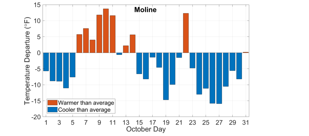
Cool weather persisted from the end of September to the first week of October across the state. As the plot below of daily temperature departures from normal in Moline shows, the second week of October was 5 to 10 degrees warmer than average across the state. However, this was followed by a predominantly cooler than average second half of the month.
Eleven daily high maximum temperature records and eight daily high minimum temperature records were broken last month. Concurrently, 66 daily low maximum temperature records and 19 daily low minimum temperature records fell in October. The cool, cloudy day of October 27 broke the month’s low maximum temperature records at seven locations in Illinois. This included the 34-degree high in Kewanee in Henry County, which broke the previous October low maximum temperature record of 36 degrees, set just last year on Halloween.

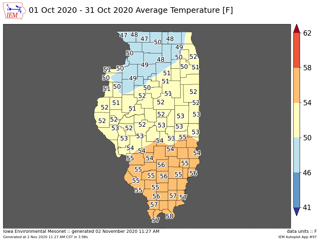
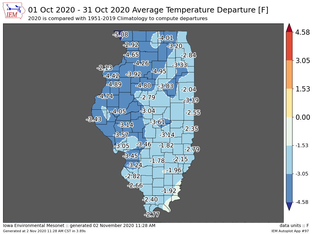
The maps below show October average temperatures and their departure from the long-term average. October average temperatures ranged from the high 40s in northwest Illinois to the high 50s in southern Illinois, between 2 and 5 degrees below average. The preliminary statewide average October temperature was 51.8 degrees, 2.6 degrees below the 30-year normal and tied for the 19th coolest on record. This follows the cooler than normal months of August and September statewide.
Harvest Fires

The combination of high temperatures, very low humidity, and strong winds created a significant fire risk during the second week of October. The plot below shows a daily mean surface vapor pressure deficit, a measure of atmospheric humidity, at Springfield between January 1 and October 18 of this year (red line) compared to all previous years (gray shaded area). A vapor pressure deficit has been linked to wildfire risk, with higher vapor pressure deficit values indicating a higher risk of wildfire outbreak.
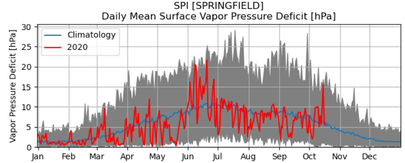
The very high values of vapor pressure deficit in Springfield, near record values on October 14, indicated a warm, dry atmosphere. Existing drought and crops drying down in fields provided ample, dry fuel for wildfire potential. Indeed, several small- to medium-sized field fires broke out across central and south-central Illinois during the second week of October.

First Snow of the Season

The map below shows the climatological earliest first measurable snowfall on record at stations across the state. The dates range from early to mid-October in northern Illinois to mid-November in southern Illinois.
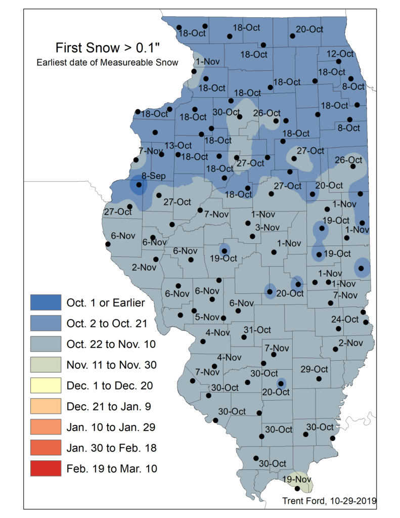
The map below shows the climatological earliest first measurable snowfall on record at stations across the state. The dates range from early to mid-October in northern Illinois to mid-November in southern Illinois.
A Wet End to the Month in Southern Illinois

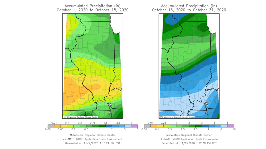
The first half of October was very dry for the southern half of the state, continuing a very dry September. However, around the middle of the month the atmosphere moved into a pattern more conducive to bringing precipitation into southern Illinois. Areas that received less than a tenth of an inch of rainfall in previous weeks saw widespread 4- to 9-inch precipitation totals during the final two weeks of October.

Belleville, for example, recorded its third wettest October with a total of 7.38 inches, following its wettest August and its second wettest July on record. At the end of October, Belleville was only 4 inches away from its wettest year on record, which was 2008 with 56.83 inches of rain.
Drought Continues in Central Illinois

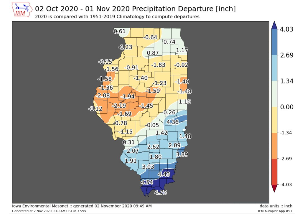
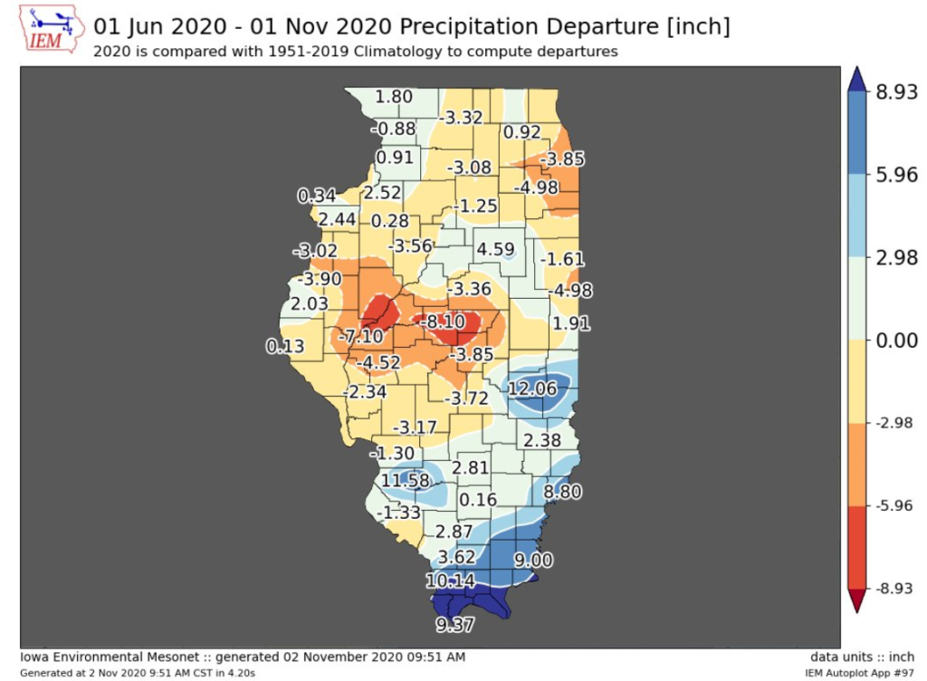
In contrast to the wet end of October in southern Illinois, much of central Illinois ended yet another month with below average precipitation. The maps below show 30- and 180-day precipitation deficits across the state. Most of central and western Illinois received between 1 and 3 inches below average precipitation in October, adding to existing precipitation deficits from dry months in August and September.

Total six-month precipitation deficits in central Illinois exceed 7 inches in Fulton and Mason Counties and 8 inches in parts of Logan and Macon Counties. At Mount Pulaski in Logan County, for example, the June 1 to November 1 precipitation deficit of 8.47 inches is the third largest on record, smaller only than 1988 and 1893. However, it should be noted that Mount Pulaski and the surrounding areas of Logan and Macon Counties received more precipitation in the first four months of this year than in all of 1988. Therefore, drought conditions, although severe, are not nearly to the extent of those in 1988.
The most recent, October 27th version of the U.S. Drought Monitor showed continued widespread moderate drought across central Illinois in response to the rainfall deficits and below normal soil moisture and streamflow.

Outlooks

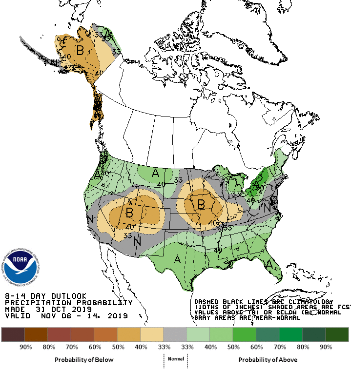
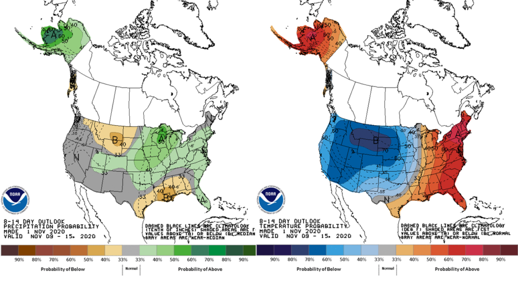
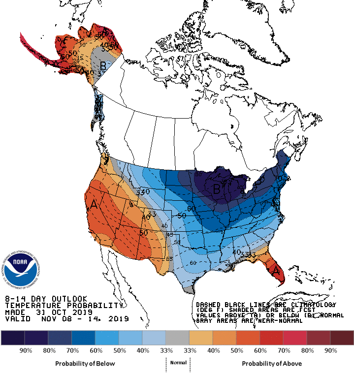
Pleasant weather is in store for the state during the first week of November. However, the Climate Prediction Center’s 8- to 14-day outlooks indicate an imminent pattern change in the second week of November, with odds moving back to below average temperatures, especially to the northwest, and above average precipitation statewide.
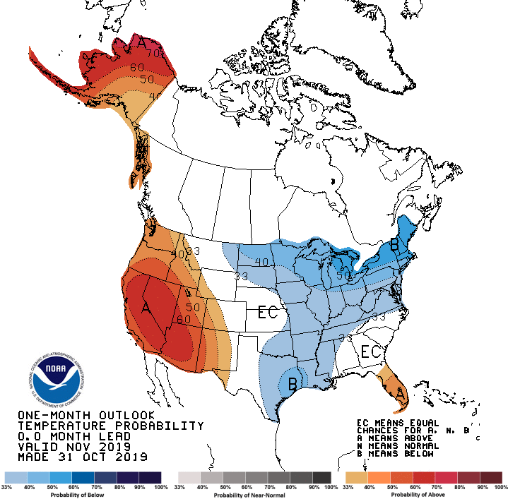
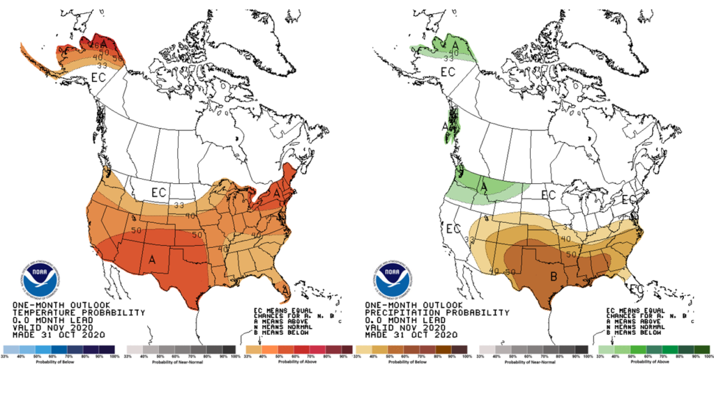
The most recent one-month outlooks for the entire month of November continue to show a strong La Niña influence, with elevated odds of warmer than normal conditions throughout the central U.S. and drier than normal weather in the south.
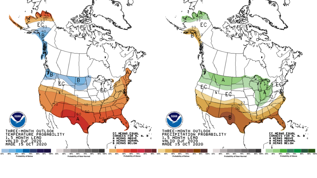
Finally, the three-month outlooks for climatological winter, December–February, show equal chances of warmer or colder than normal conditions in Illinois. However, the odds increase for wetter than normal conditions later in winter.
A Cool Start to Fall

September was slightly cooler and wetter than average across Illinois. The preliminary statewide average September temperature was 65.4 degrees, 0.8 degrees below the 30-year normal, and tied for the 45th coolest on record. Preliminary statewide average total precipitation for August was 3.39 inches, 0.16 inches more than the 30-year normal, and the 58th wettest on record.

Data are provisional and may change slightly over time

September Temperatures

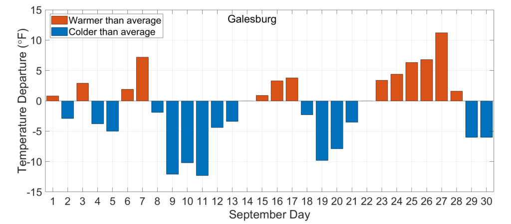
A cold front moved through the Midwest in late August, bringing Illinois its first real taste of fall air. Below average temperatures remained in place for most of September, resulting in an overall statewide average temperature of 65.4 degrees, 0.8 degrees below the 30-year normal.

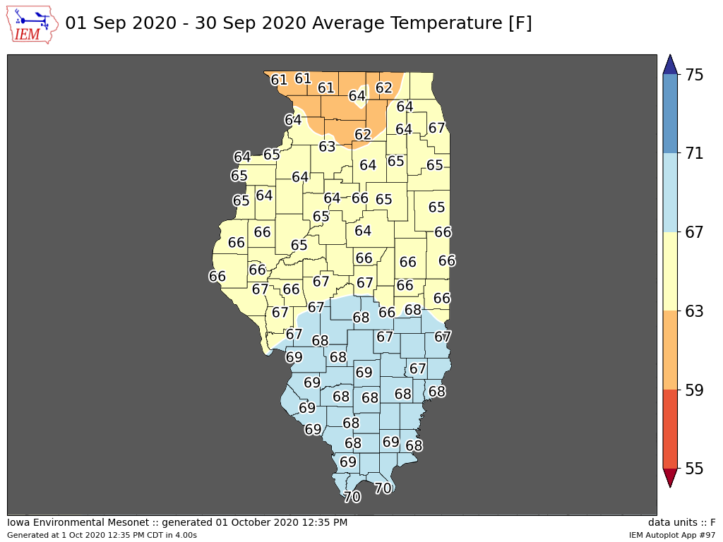
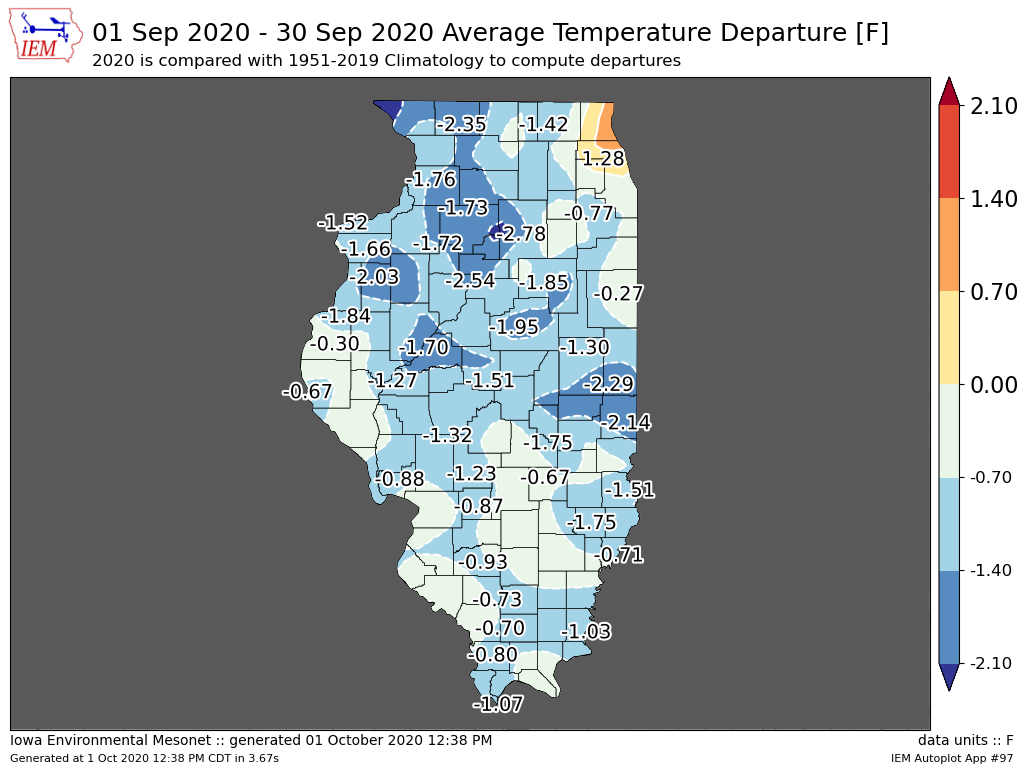
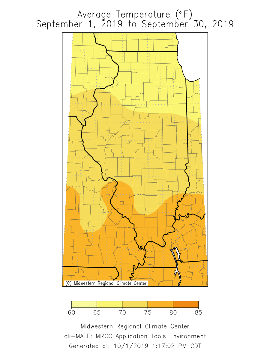
The maps below show September average temperatures and their departure from the long-term average. September temperatures ranged from the low 60s in northern Illinois to the low 70s in far southern Illinois. All but the very northeastern corner of the state was cooler than average, including parts of Putman and LaSalle Counties, which were nearly 3 degrees below the long-term September average temperature.

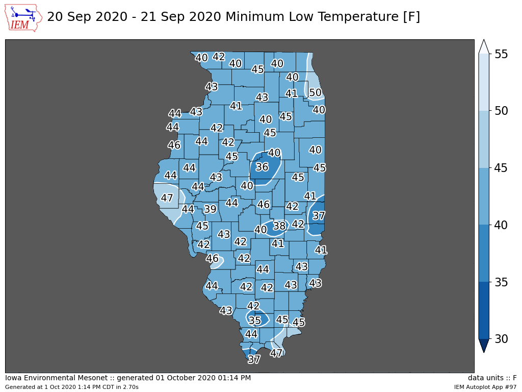
Although temperature departures were largest in northern Illinois, the southern half of the state experienced unusually cold weather during the third week of September. The map below shows observed minimum temperatures on September 20. The station in Cairo in Alexander County observed 37 degrees that morning, which broke the all-time September minimum temperature record in Cairo set in 1989.

Western U.S. Wildfire Smoke

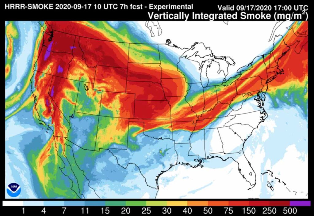
On several otherwise cloud-free days last month, the sky over Illinois appeared an odd milky-white color. This was caused by smoke from wildfires in the western U.S. that had moved across the country. The figure below shows a satellite estimate of vertically integrated smoke across the U.S. on September 17. Areas with relatively high smoke content in the atmosphere are shown in red and pink. Although the smoke created an eerie appearance in the sky, it did not pose a health risk to Illinoisans. The smoke though did likely, although modestly, suppress our daytime high temperatures last month as it reduced the amount of sunlight reaching the surface and heating the afternoon air.

Southern Illinois’ Turn for Drought

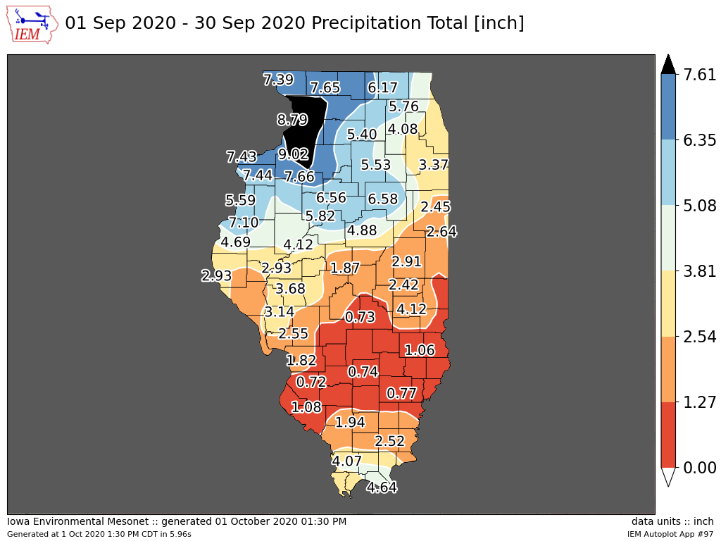
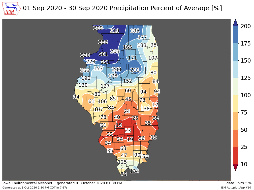
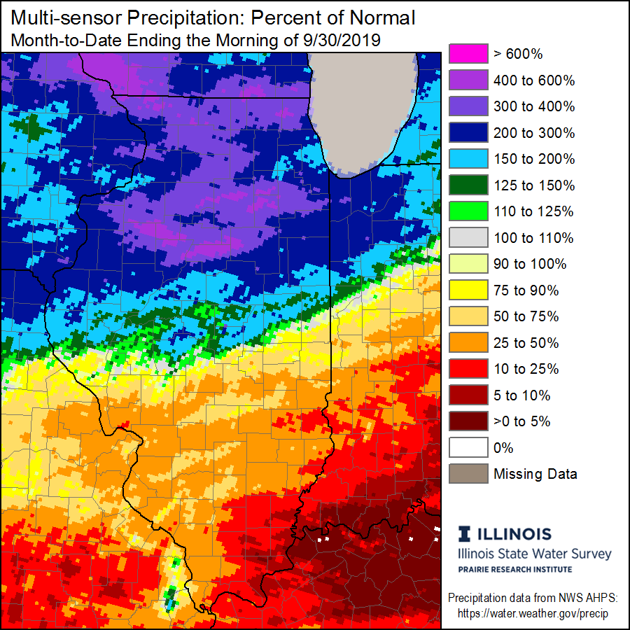
September statewide total precipitation was 3.39 inches, approximately 0.16 inches above the long-term average. However, much like the previous three months, large precipitation gradients created rainfall winners and losers. The maps below show total September precipitation and September precipitation percent of normal.

Total September rainfall ranged from over 9 inches in northwest Illinois to less than a half inch in eastern Illinois. Most areas of northern Illinois experienced between 125 percent and 300 percent of normal September precipitation, while areas of southern Illinois experienced between 10 percent and 90 percent of normal.

On one end of the extreme, the station at the Quad Cities airport in Moline experienced its 10th wettest September with a total of 6.25 inches. This followed the driest August on record in Moline, with only 0.15 inches of total August precipitation. This is contrasted by the station in Paris in Edgar County, which observed only 0.34 inches of total precipitation in September, making it the third driest September on record in Paris. This came after the second wettest July on record in Paris, with over 10 inches of precipitation.

However, Belleville in St. Clair County wins the prize of most variable rainfall over the past few months with the second wettest July on record, followed by the wettest August on record, followed by the seventh driest September on record.

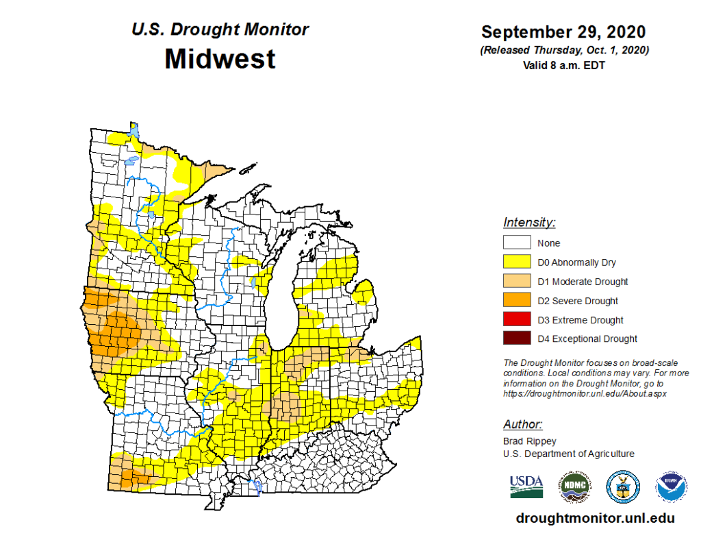
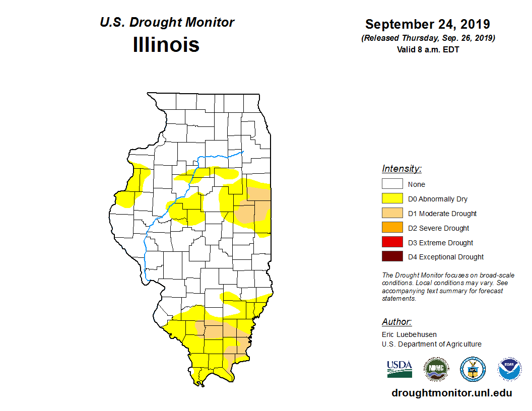
The rainfall in northern Illinois was welcome, and alleviated drought conditions that had persisted there since early August. However, the very dry conditions in central and southern Illinois resulted in an expansion of moderate drought and abnormally dry conditions in the most recent, October 1 edition of the U.S. Drought Monitor (map below).

Outlooks

The first few days of October have continued the cool weather in September. However, outlooks from 6 to 10 days out to 3 months are indicating the highest odds for warmer than normal conditions.

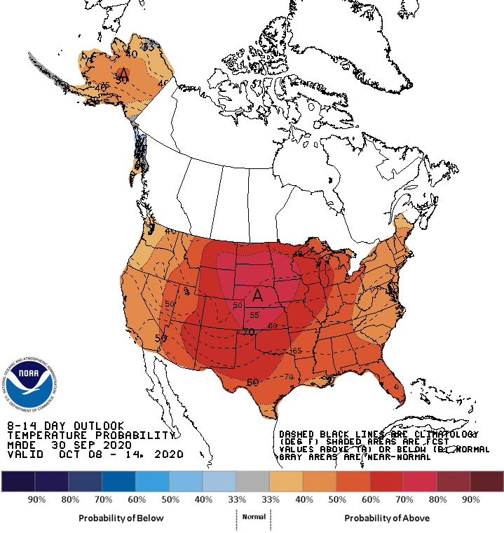
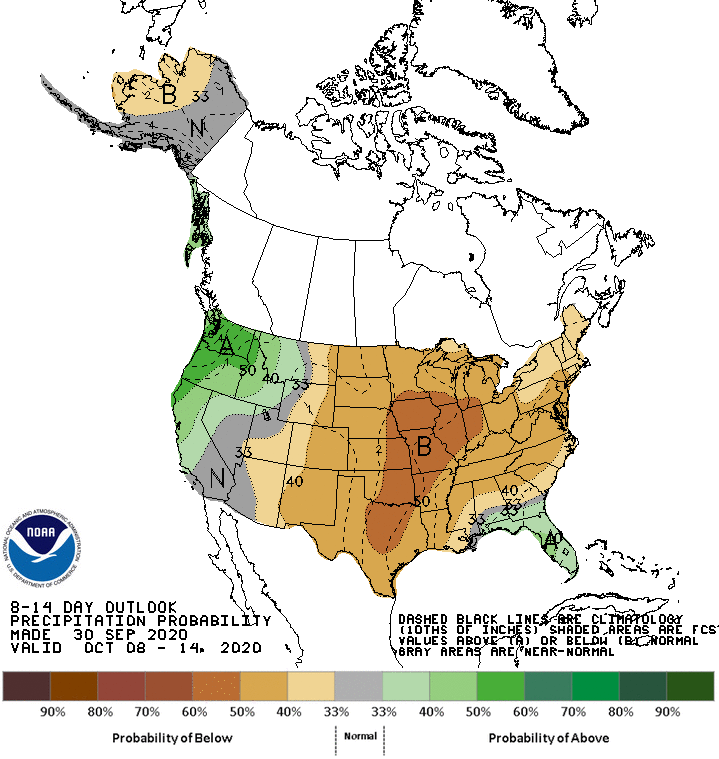
The 8- to 14-day outlooks below indicate strongly elevated odds of warmer and drier than normal conditions in the second week of October across the state. Although this will not help alleviate ongoing drought in central and southern Illinois, it will help crop dry down as we enter the peak harvest season.

Looking farther out, the week three to four outlooks are similar with warmer and drier than normal conditions prevailing for the latter part of October.

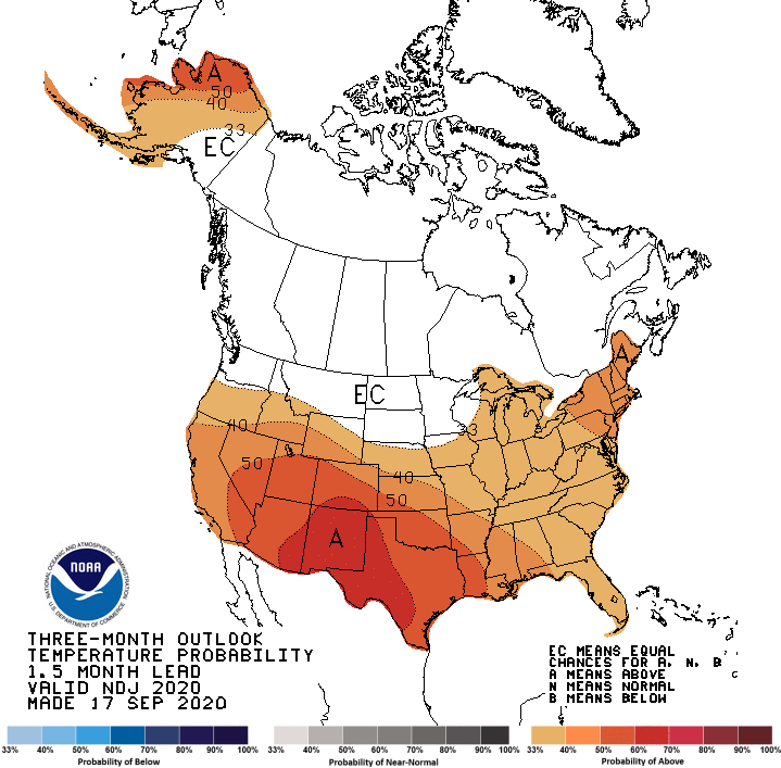
As we begin to look toward climatological winter, the three-month outlooks for November, December, and January are still tilted toward warmer than normal conditions. Precipitation outlooks for the same three-month period show an equal chance of wetter and drier than normal weather. 

October: Heat to Snow

We saw highly variable temperatures across the state this month, with record-breaking heat in the early part of October, and record-breaking cold in the latter part. The preliminary statewide October average temperature was 53.7 degrees, less than 1 degree below our 30-year normal. Temperatures were near normal in eastern Illinois, and between 2 and 6 degrees below normal across western Illinois. Preliminary data suggest October was considerably wetter than normal for the entire state. The statewide average October precipitation total was 5.20 inches, approximately 2 inches above the 30-year normal. The wet deviations were particularly large in the northern and southern reaches of the state.

Data are provisional and may change slightly over time

Temperature Variability

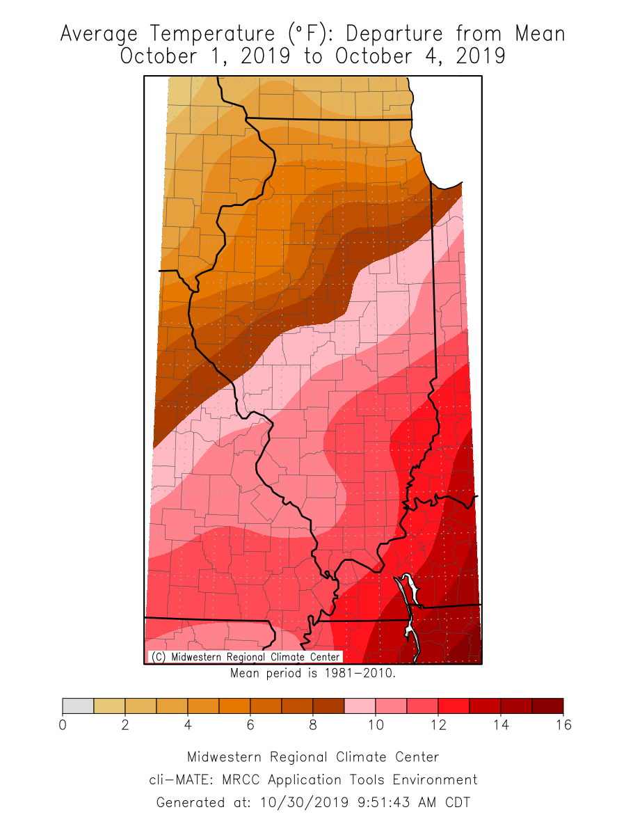
Record-breaking high temperatures persisted from September into early October. Average temperatures during the first four days of October were 10 to 14 degrees above normal in the southeast part of the state, and 3 to 8 degrees above normal for the northwest part (see map below). Maximum temperatures broke 90 degrees and minimum temperatures remained in the 70s for several days in southern Illinois. Stations in Saint Clair and White Counties reached 96 degrees on October 2.  Between October 1 and October 4, 46 daily high maximum temperature records and 73 daily high minimum temperature records were broken across Illinois, according to the NOAA National Centers for Environmental Information (NCEI). Additionally, 9 stations broke their all-time October high maximum temperature records, and 13 stations broke their all-time October high minimum temperature records. In one particularly extreme event, the October 1 nighttime minimum temperature at Kaskaskia Lock and Dam in Randolph County was 72 degrees, 10 degrees above the previous daily record and 2 degrees above the all-time October minimum temperature record at that station.

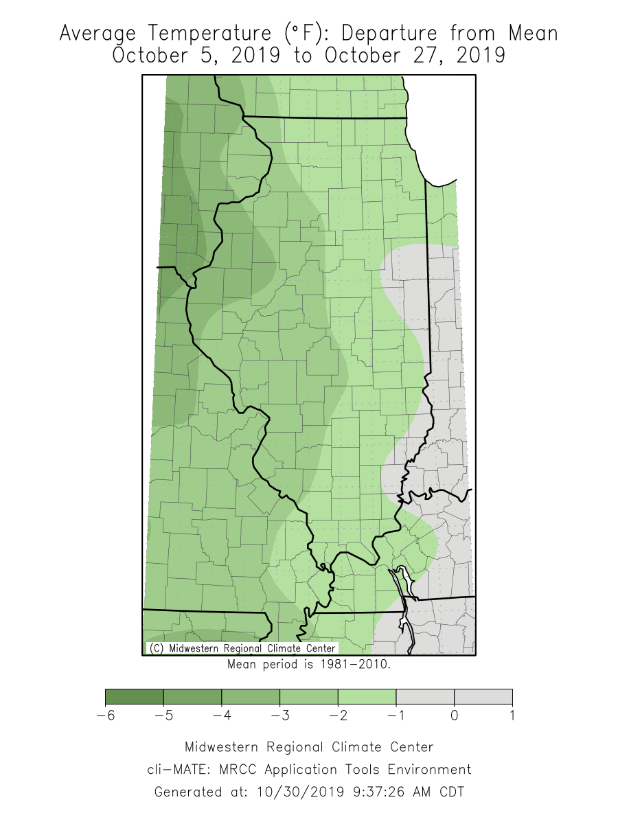
Seasonable temperatures ensued after the heat was broken toward the end of the first week of October. Temperatures from October 5 to October 27 were near normal in eastern Illinois and between 3 and 6 degrees below normal for western Illinois (see map below). Nearly all the state experienced the first fall frost event in the second week of October. Nighttime minimum temperatures dipped below 32 degrees as far south as Pope County and below 28 degrees in Warren and Jo Daviess Counties.

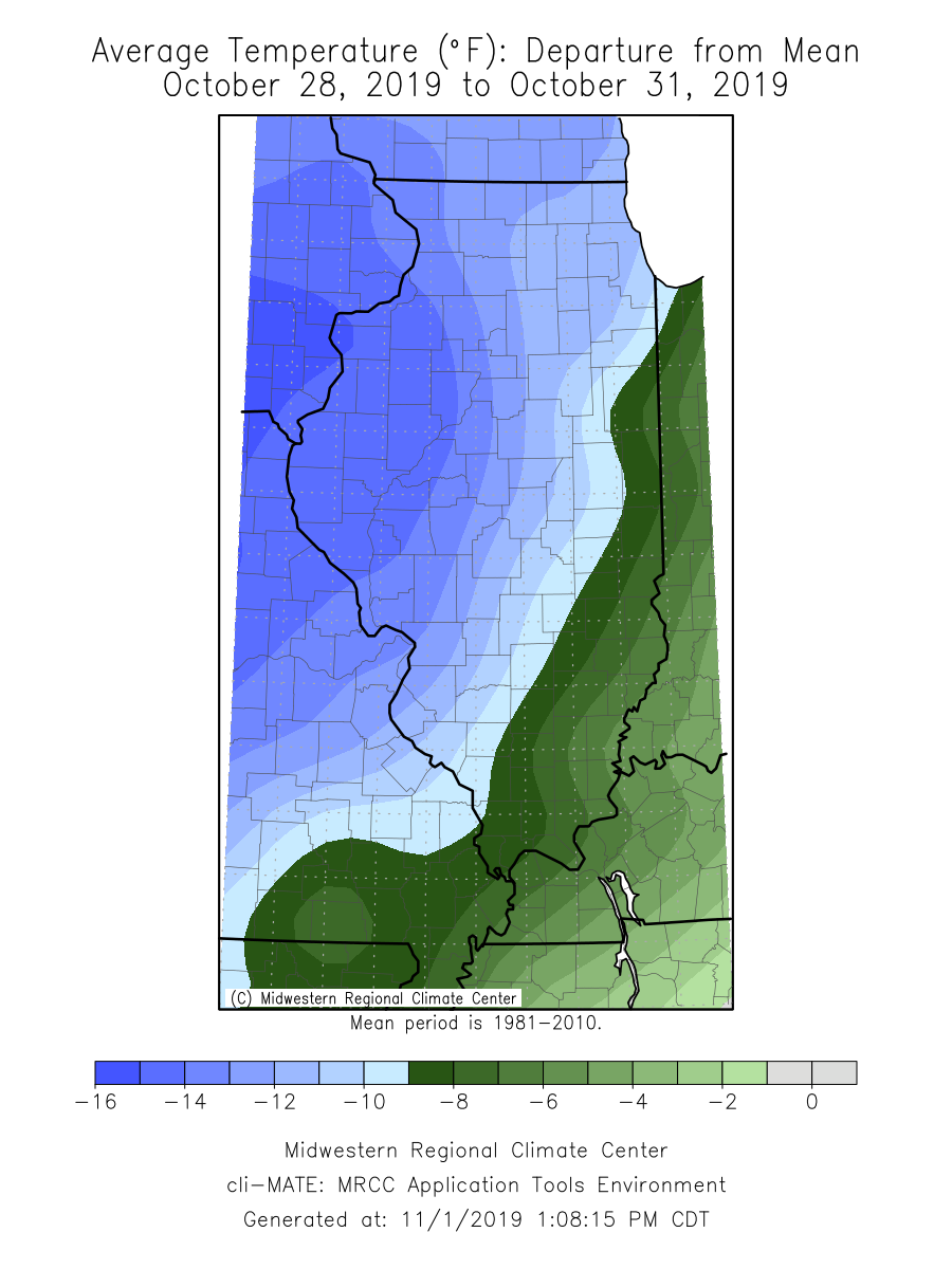
The heat wave that started the month was matched by a strong burst of cold air to close out the month. Temperatures between October 28 and October 31 were 8 to 16 degrees below normal. Similarly, 48 daily low maximum temperature records and 12 daily low minimum temperature records were broken across Illinois over the last four days of the month. Nighttime minimum temperatures dropped below 30 degrees as far south as Pulaski County. The lowest minimum temperature observed in October was 14 degrees in both Carroll and Lee Counties on Halloween night. Halloween was also the coldest on record for 51 stations across Illinois.

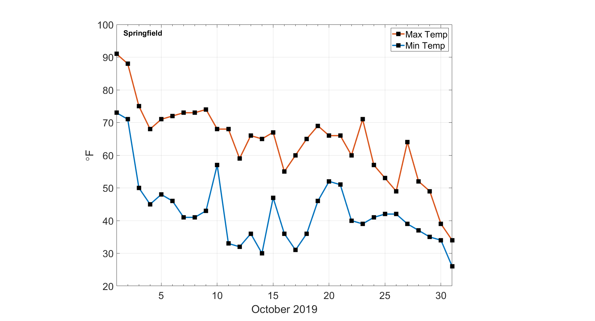
The temperature contrast between the start and end of this month may be best summarized in the graph below, which shows daily maximum and minimum temperatures at Springfield Abraham Lincoln Capital Airport this last month. There was a 57° difference between daily maximum temperatures on October 1st and October 31st in Springfield, both of which broke daily records. In fact, 10 Illinois COOP stations broke their daily high maximum temperature record on October 1st and their daily low maximum temperature record on October 31st.

Precipitation

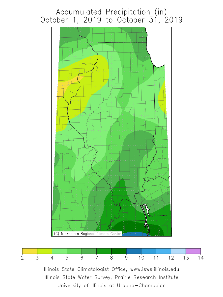
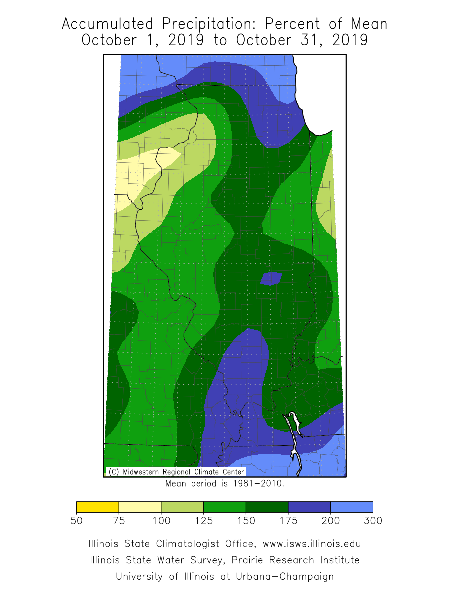
October precipitation was above normal for virtually all of Illinois. The statewide total precipitation in October was 5.20 inches, approximately 2 inches more than the 30-year normal. Areas of far northern and southern Illinois received over 7 inches of rainfall in October. CoCoRaHS observers in New Lenox in Will County and Riverwoods in Lake County recorded over 12 inches of precipitation in October. Expressed as a percent of the long-term mean, areas of northeastern Illinois received more than 200 percent of mean October precipitation, and a broad swath of southern Illinois received over 150 percent of mean October precipitation (see maps below). Significant rainfall helped improve drought conditions in southern Illinois. The latest U.S. Drought Monitor map – current as of October 29 – shows no drought in Illinois for the first time since early August.

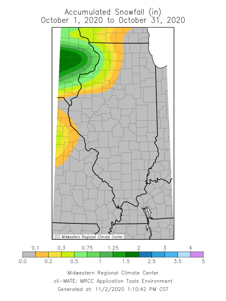
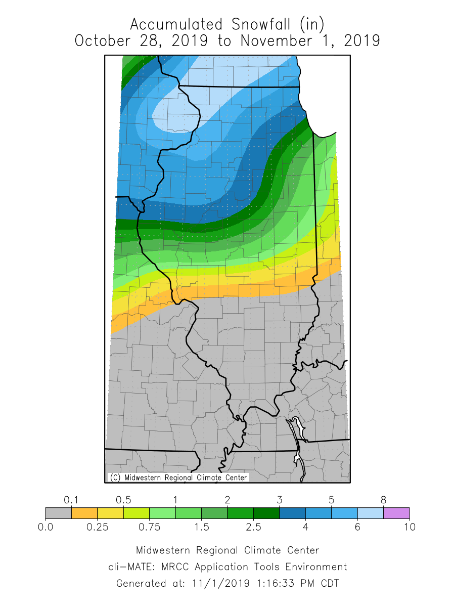
The cool down that came at the end of this month brought a variety of precipitation, including snowfall and some snow accumulation in northern and western Illinois. Total snowfall accumulation over the last week of October ranged from over 8 inches in northwestern Illinois to just over a tenth of an inch as far south as Nokomis in Montgomery County. The highest October snowfall total, 8.5 inches, was in Orangeville in Stephenson County. Although late October is early for the first snowfall in Illinois, it is certainly precedented. The map below shows the date of the earliest recorded snowfall (> 0.1 inch) at COOP stations across the state.
Short- and Long-Term Outlooks

Short-term 8- to 14-day outlooks from the Climate Prediction Center show strongly elevated odds of below normal temperatures persisting into the first couple of weeks of November. Concurrently, probabilities are elevated for below normal precipitation out to 14 days, as drier weather is likely to prevail following the first winter storm of the season in Illinois.

Longer-term outlooks for November also show increased odds of below normal temperatures and increased odds of above below normal precipitation. Winter (December–February) outlooks show greater odds of a wetter than normal winter.


September Heat, Flooding, & Drought

This past month was tied for the 4th warmest September for Illinois (state average temperatures back to 1895), and the warmest September since 1933. Precipitation varied tremendously from north to south across the state.

Preliminary data suggest that September was tied for the 4th warmest on record for Illinois. The preliminary average statewide September temperature was 71.3 degrees, which is 4.9 degrees above the long-term average. Monthly temperatures ranged from 2 to 4 degrees warmer than normal in northeast Illinois to over 6 degrees warmer than normal in southwest Illinois. The preliminary average statewide precipitation was 5.34 inches, which is 1.9 inches above the long-term September average. However, the data also show large differences in September precipitation totals across the state, with northern Illinois receiving much more than average precipitation, and southern Illinois receiving much less than average.

Data are provisional and may change slightly over time. 

Precipitation, Flooding, & Drought

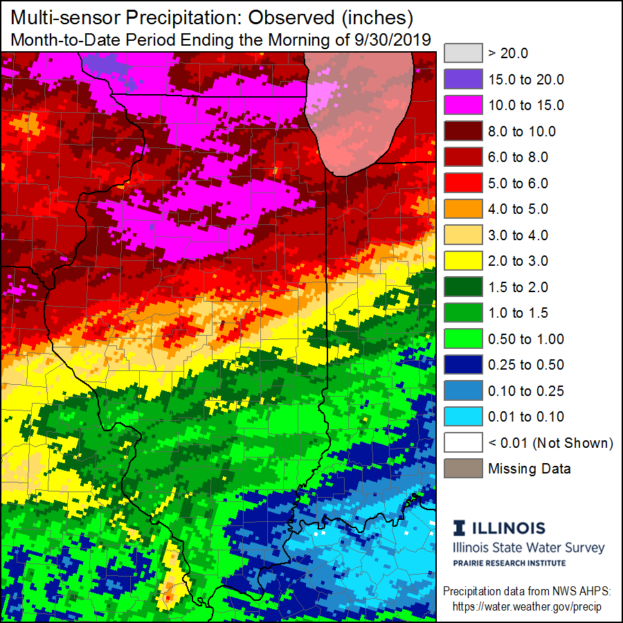
September precipitation totals reveal a strong north-to-south gradient. Areas of northern and north-central Illinois received in excess of 12 inches of rainfall in September, while areas of southeast Illinois received less than 0.25 inches over the same time period (see maps below). Expressed as a percent of normal September precipitation, these totals ranged from 300 percent of normal in northern Illinois to less than 5 percent of normal in southeast Illinois. Locally, a station near Stockton (Jo Daviess County) observed 16.62 inches in September (nearly 13 inches more than normal), while the station at Smithland Lock & Dam (Pope County) recorded only 0.02 inches (3.5 inches less than normal).

August 2019 was the first months since September 2018 during which the U.S. Drought Monitor identified drought in the state. In September, dryness in east-central Illinois persisted but did not intensify. The latest U.S. Drought Monitor map (September 24) shows a pocket of moderate drought covering parts of Champaign, Ford, Iroquois, and Vermilion counties (see map below). Concurrently, below normal rainfall and above normal temperatures in the southern part of the state produced dryness in September. The latest U.S. Drought Monitor depicts abnormally dry conditions for most of Illinois south of I-64, and a pocket of moderate drought from Pope and Hardin counties in the southeast to Perry and Franklin counties in south-central Illinois. Conditions in southern Illinois have shown some signals of a flash drought, which is a rapidly intensifying drought event, often provoked by existing precipitation deficit combined with intense heat.

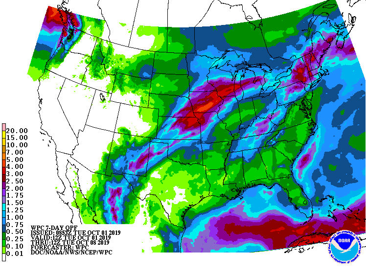
Reports from Illinois Farm Bureau CropWatchers regarding drought in east-central and southern Illinois are mixed. Some report the dryness and heat have helped late-planted crops reach maturity, while at the same time possibly sacrificing yield. The recent National Weather Service 7-day precipitation forecast calls for 1 to 4 inches of rain in the northern half of the state, with 7-day forecasted totals less than 0.5 inches in southern Illinois (see map below).

In contrast to the ongoing drought in southern and east-central Illinois, September was abnormally wet for most of northern and north-central Illinois. Persistent, heavy rains led to flooding impacts in parts of northern Illinois, including the closure of several state parks and significant flooding along the Fox and Des Plaines Rivers, among others. Areas in northern and north-central Illinois received in excess of 12 inches of rainfall in September. In most parts of Peoria, Woodford, Marshall, and Livingston Counties, most of the rainfall totals came in a 24-hour period between September 27 and 28. This event created dangerous flash flooding from Peoria into the southwest Chicago suburbs.

The COOP station in Minonk, Illinois (Woodford County) recorded 9.09 inches of rainfall over that 24-hour period, although that likely fell over a less than 12-hour window. This total approached the 24-hour, 500-year storm total of 9.53 inches and surpassed the 12-hour, 500-year storm total of 8.29 inches. A 500-year storm total refers to a precipitation accumulation over a given time period (e.g., 12, 24, 48 hours, etc.) and has a 0.2 percent chance of occurring in a given year. Impressively, the 9.09-inch total in Minonk broke, and nearly doubled, the all-time 24-hour precipitation total record at that station, which was just over 5 inches (data going back to 1895). Images of flooded fields in Woodford and Marshall Counties suggest this most recent heavy precipitation event may delay harvest.

Temperature


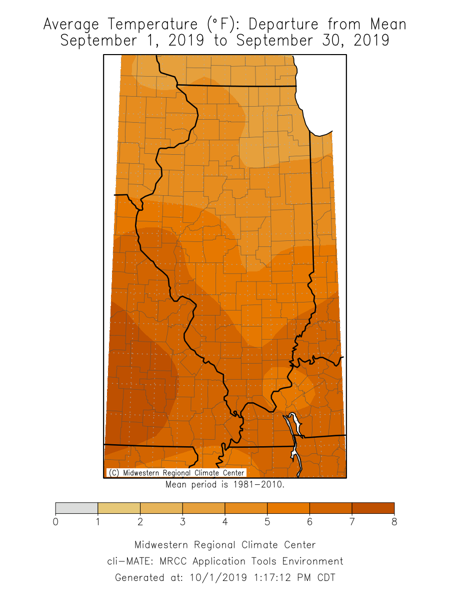
The September temperature was much more consistent across the state than precipitation, as the entire state experienced above normal temperatures this month (see maps below). Apart from the last full week in September, most of the state has been under the influence of a large high-pressure system this month, centered to our southeast. This system has allowed warm air to intrude from the south/southwest, generating warmer than normal conditions for this time of the year. In fact, the statewide September average temperature was 71.3 degrees, tying it for the 4th warmest September on record in Illinois (back to 1895). September average temperatures across the state ranged from 65 degrees in Jo Daviess County to 78 degrees in Lawrence County. The lowest minimum temperature reported in Illinois in September was 45 degrees in Jo Daviess County on September 5, and the highest maximum temperature reported in Illinois was 97 degrees in both Alexander and Pope Counties on September 16. Well over 100 local daily climate records were broken in Illinois in September, most of which were high daily minimum temperature records. This is attributed to several very warm nights, including the night of September 22, when the nighttime minimum temperature remained above 70 degrees as far north as Elizabeth (Jo Daviess County) and Freeport (Stephenson County). On the night of September 10, the station in Rock Island reported a nighttime minimum temperature of 77 degrees, besting the previous daily record by 3 degrees.

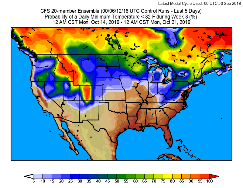
Short-term temperature forecasts call for continued above average temperatures for the first few days of October and then a regression to cooler, more seasonal conditions. Longer term Climate Forecast System (CFS) forecasts from the National Centers for Environmental Protection show probabilities of a 32-degree freeze in Illinois remain below 30 percent into the third week of October. The map below shows the probability of a daily minimum temperature below 32 degrees between October 14th and October 21st.

October 2019 Outlook


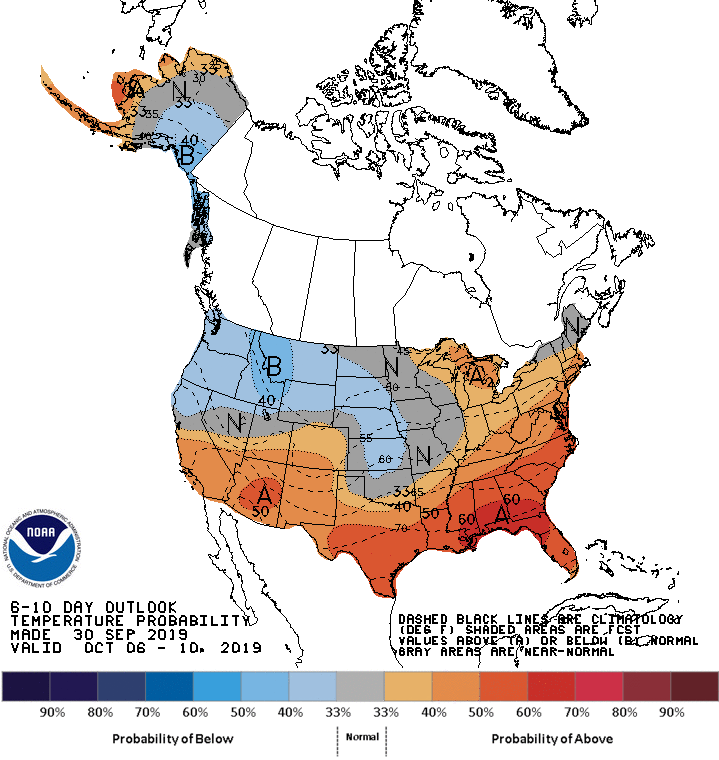
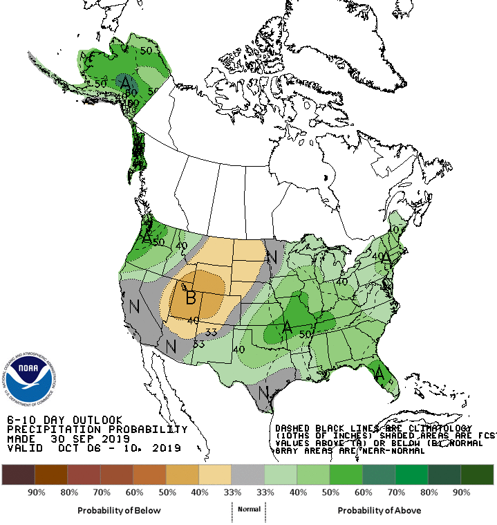
Looking into October, the 8 to14-day outlook from the Climate Prediction Center (CPC) shows elevated probabilities of above normal temperatures and elevated probabilities of above normal precipitation across the state.

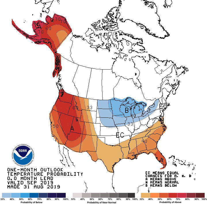
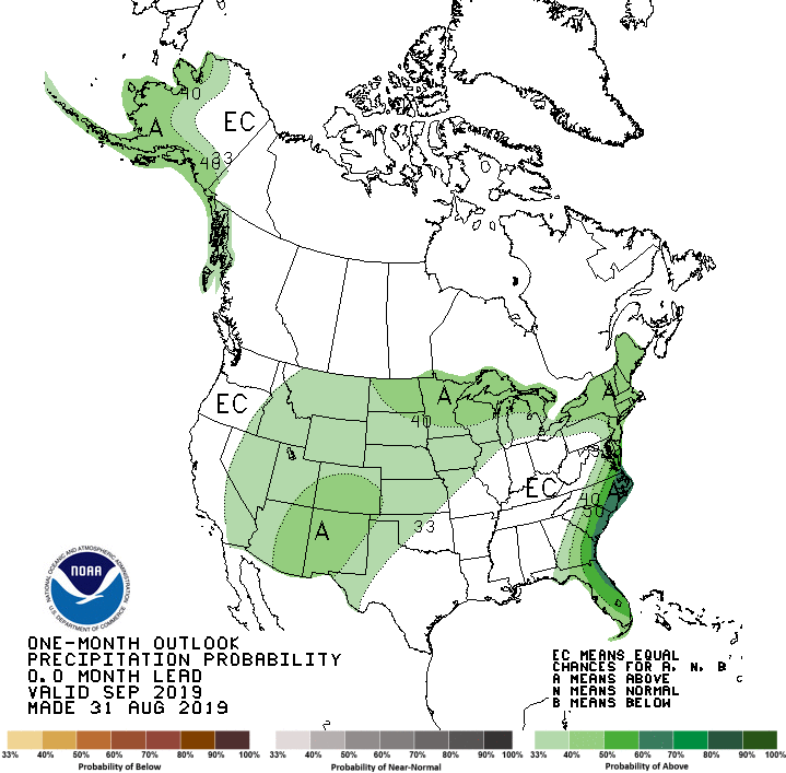
The CPC monthly outlook for October still shows elevated probabilities for below normal temperatures across the northern half of the state, with equal chances (above normal, normal, below normal precipitation) for all but the very northwest corner of Illinois (see maps below).