Rain At Last in Illinois

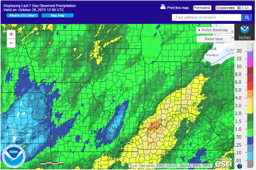
Here is the rainfall map for the past 7 days. Most of the rain in Illinois has come in the last 2 days of that mapping period. In fact, almost all the rain in October for Illinois has fallen in the last 2 days.

Most of Illinois was in the two lighter shades of green, indicating rainfall amount of between 0.5 and 1.5 inches. There is a hole in southwestern Illinois (blue) were rainfall amounts were less than 0.5 inches. Higher amounts of 2 or more inches just missed Illinois, and fell across the border in Kentucky and southern Indiana.

It looks like we have one last shot of rain in October on Saturday.

Click to enlarge.
Click to enlarge.

Second Driest October on Record for Illinois, But Not for Long

As of this morning, the statewide average precipitation in Illinois was 0.34 inches. That makes it the second driest October on record. However, the forecast for Tuesday will move us down in the rankings. In the meantime, here is where we stand for dry Octobers:

Rank Year Amount Departure Percent of Average
1 1964 0.18 -3.06 6%
2 2015 0.34 -2.90 11%
3 1897 0.46 -2.78 14%
4 1908 0.50 -2.78 15%
5 1895 0.60 -2.64 19%
6 1952 0.67 -2.57 21%
7 1904 0.71 -2.53 22%
8 1956 0.72 -2.52 22%
9 1915 0.83 -2.41 26%
10 1963 0.93 -2.31 29%

First Freeze of Season Hits Illinois

Over the weekend, most areas of the state saw their first taste of 32 degrees or colder. Here are the maps from the Midwestern Regional Climate Center showing that the almost the entire state was covered. A few places in the Chicago area may have escaped thanks to the so-called Urban Heat Island (UHI) – lots of warm surfaces like roads, asphalt parking lots, roofs, and waste heat from buildings. For example, O’Hare AP reached 33 degrees. Meanwhile, Mt. Carroll in northwest Illinois reported 20 degrees on October 18. Now that’s cold.

frost-northfrost-south