

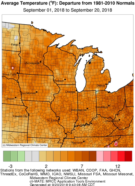
Illinois and the Midwest have been running hot so far in September. The statewide average temperature for September 1-19, 2018, in Illinois was 73.5 degrees and 4.7 degrees above normal.
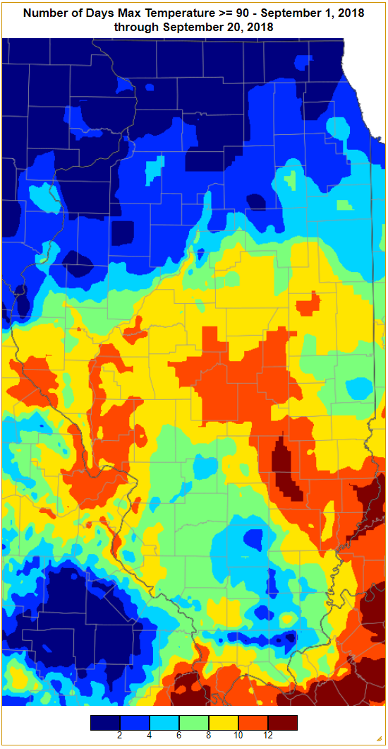
Days at or above 90 degrees have been quite common this September, especially in central and southern Illinois where we saw 8 to 12 days with temperatures at or above that threshold. Runs of hot weather like this in September are unusual but not necessarily record-breaking. For example, here in Champaign, we have reached the 90-degree threshold 10 times this month (including today). That’s the 4th highest count for September since 1888. The highest number of days was 15 set in 1897.
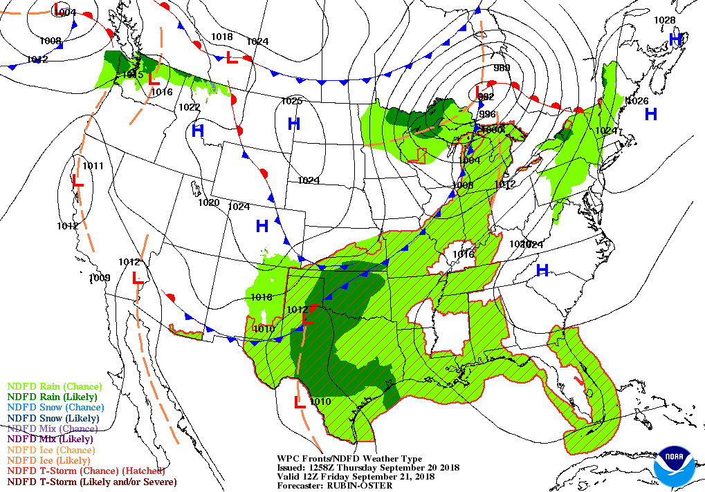
But this is about to change on Friday as a cold front sweeps across the state. Here is the forecast map for Friday morning with rain ahead of the front and cooler temperatures behind the front. The NWS forecasts out to 14 days show that colder-than-normal temperatures will prevail with highs in the 60s and 70s and lows in the 40s and 50s across much of Illinois.
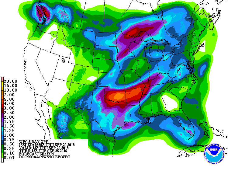
From a harvest standpoint, the rains over the next five days may impact harvest with the heavier amounts expected in southern Illinois with potential amounts of 1 to 2 inches south of Interstate 70. The expected amounts are much less in central and northern Illinois. A look at the 6-10 and 8-14 day forecasts suggest that Illinois will continue to be in a wetter pattern with above-normal precipitation and below-normal temperatures.
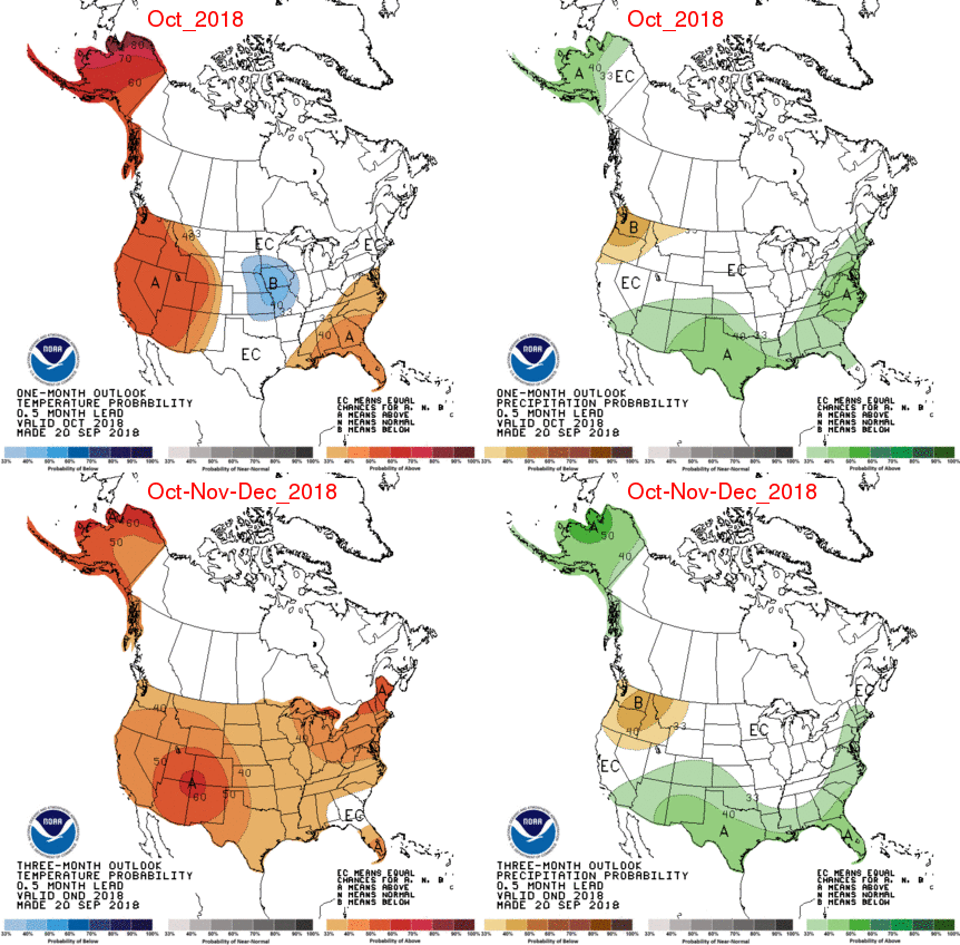
The NWS also released their latest outlooks today. For October there is a “blob” of cooler-than-normal conditions centered over Iowa and Missouri and includes western Illinois. Illinois has “equal chances” or EC on precipitation, meaning there is not an increased chance of either above or below normal precipitation.
For October-December, Illinois has an increased chance of above-normal temperatures. There is not an increased chance of either above or below-normal precipitation. For the most part, the temperature pattern for October-December is based on climate trends (warming) and the odds favoring the arrival of El Niño this fall and winter.
Wet Start to September Thanks to Gordon
Illinois experienced a wet start to September, thanks in part to Tropical Storm Gordon. The statewide average rainfall through yesterday morning was 3.55 inches. That is above the 3.24 normal rainfall for the entire month of September. The highest month-to-date rainfall total was 10.15 inches and came from Clay City (east of St. Louis).
Continue reading “Wet Start to September Thanks to Gordon”
Both August and Summer Were Warmer, Wetter Than Normal for Illinois
August: the statewide average temperature for Illinois in August was 74.9 degrees, 1.3 degrees above normal. The statewide average rainfall was 5.25 inches, 1.66 inches above normal and the 12th wettest August on record.
The warmest daily high temperature was 97 degrees reported at Chicago Botanical Gardens (8/5), Chicago O’Hare (8/4), Jerseyville (8/7), and Pittsfield (8/29). The coolest reading was 42 degrees reported at Rochelle (8.22).
Continue reading “Both August and Summer Were Warmer, Wetter Than Normal for Illinois”
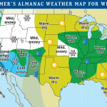
Battle of the Winter Forecasts
What the Almanacs Say
Recently, both the Farmer’s and Old Farmer’s Almanacs released their winter forecasts (below) and what they say for Illinois is quite different. The Farmer’s Almanac predicts a “Biting Cold, Snowy” winter while the Old Farmer’s Almanac predicts a “Warm, wet” winter for Illinois.
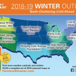
The Farmer’s Almanac states that it “bases its amazingly-accurate long-range forecast on a mathematical and astronomical formula developed in 1818”. We have learned quite a bit about the weather since then. And the phrase of “biting cold, snowy” can describe a typical morning in January and February.
Continue reading “Battle of the Winter Forecasts”