The preliminary statewide average December temperature was 39.4 degrees, 9.6 degrees above the 1991–2020 average and the second warmest on record going back to 1895. The preliminary statewide average total December precipitation was 2.70 inches, 0.02 inches above the 1991–2020 average and tied for the 40th wettest on record.
Data are provisional and may change slightly over time
Unusually Warm December
December is the first month of climatological winter, but the weather felt more like an extension of fall throughout most of the month.
Figure 1 shows daily temperature departures from normal in Quincy. Most December days in Quincy were between 10 and 30 degrees warmer than normal, making last month the second warmest December on record in Quincy. December was also the warmest on record in Carbondale, the third warmest on record in St. Louis, Springfield, and Peoria, the fourth warmest in Rockford and Champaign-Urbana, and the fifth warmest in Chicago.
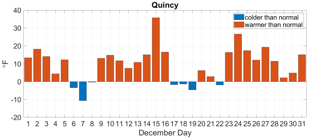
Figure 1. Daily December average temperature departures in Quincy.
December average temperatures ranged from the low 30s in northern Illinois to the high 40s in southern Illinois, between 6 and 12 degrees above normal (Figure 2). High temperatures regularly reached into the 70s last month in southern Illinois, including a 78-degree high in Randolph County on December 4. Carbondale recorded 74 degrees on December 25, one of the warmest Christmas Day temperatures on record in the state. Although fleeting, we did see very cold temperatures in December, including nighttime lows in the single digits across much of northern Illinois.
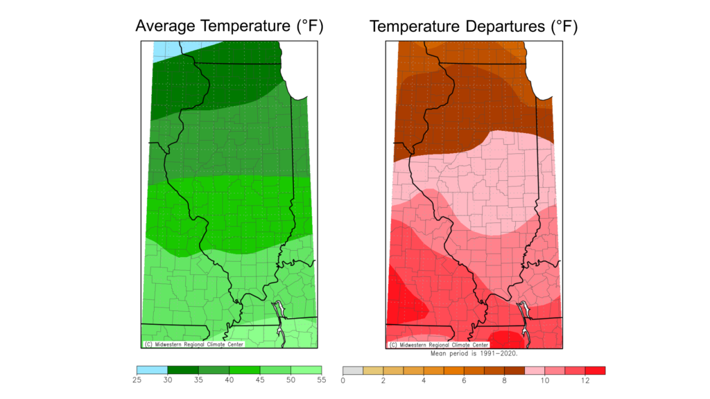
Overall, the preliminary statewide average December temperature was 39.4 degrees, 9.6 degrees above the 1991–2020 average and the 2nd warmest on record going back to 1895.
Where is the Snow?
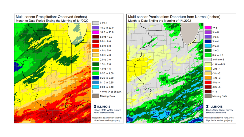
November was drier than normal virtually everywhere in the state, and that dryness persisted in December for the western half of the state. Total December precipitation ranged from around 1 inch in far western Illinois to nearly 6 inches in far southeast Illinois (Figure 3). Most of western Illinois was 0.50 to 1.5 inches drier than normal, whereas eastern and southern Illinois were near to 0.50 inches wetter than normal for the month.
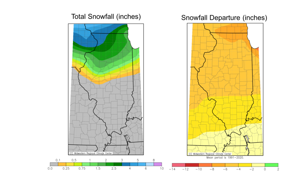
Snowfall essentially requires two ingredients: (1) cold-enough temperatures to permit the snow to reach the ground and (2) enough moisture in the air to precipitate as snow. In December we generally had enough moisture in the air, but the persistently warm weather ensured most of the month’s precipitation was in liquid form. Consequently, snowfall was 1 to 8 inches below normal in December. Snow totals ranged from 4 inches in far northwest Illinois to 0 south of Interstate 72 (Figure 4).
Many places did not record their first measurable snow until the last week of the month. Chicago recorded their first measurable snowfall of the season on December 28, eight days later than the previous recorded latest first snowfall (December 20, 2012). Most places in south-central and southern Illinois did not record any measurable snowfall in December, including in Springfield. The capital city has made it to January 1 without measurable snowfall only twice in its 120-year record, in 1912 and in 2020.
With the liquid water content of snow and rainfall taken together, the preliminary statewide average total December precipitation was 2.70 inches, 0.02 inches above the 1991–2020 average and tied for the 40th wettest on record.
December Severe Weather
Severe weather, including tornadoes, hail, and strong winds, tend to have the highest frequency in Illinois between April and June. However, unlike Atlantic hurricanes or extreme cold, Illinois does not have a “tornado season” because tornadoes and other severe weather can and do occur all year in the Land of Lincoln. This past month we got an awful reminder of this fact.
The exceptionally warm weather and large-scale dynamics in December made for conducive conditions for severe weather, and indeed we had more than our fair share of severe weather last month. The most noteworthy event was on the night of December 10, when severe thunderstorms moved across the southern Midwest and the mid-south, resulting in multiple very strong tornadoes in Illinois, Missouri, Arkansas, Tennessee, and Kentucky.
The tornado outbreak was responsible for dozens of fatalities across the area, including six deaths in Illinois, many injuries, and damage or destruction to thousands of homes and structures. More details on the Illinois-side of the severe weather outbreak are here: https://stateclimatologist.web.illinois.edu/2021/12/16/the-december-2021-tornado-outbreak-in-illinois/.
Overall, the NOAA Storm Prediction Center shows nine tornado reports in Illinois for December. Illinois averaged just over one December tornado per year between 1950 and 2020.
Outlooks
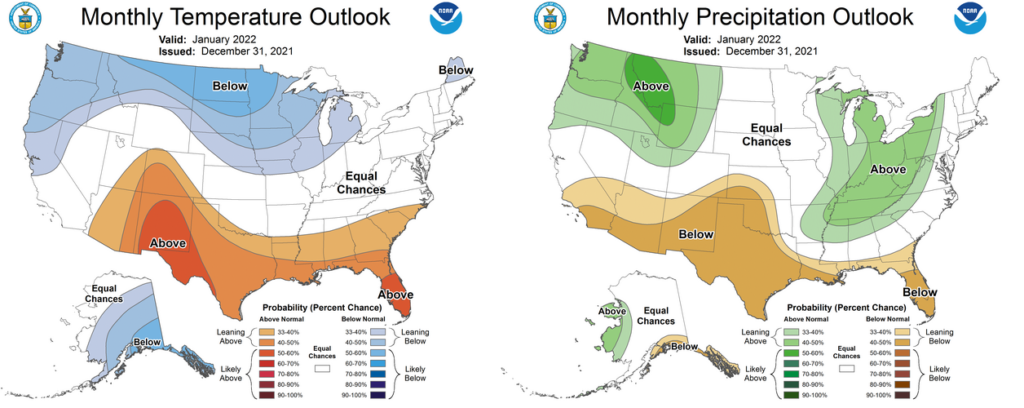
After a wimpy start to climatological winter, near and longer term outlooks are indicating the potential for real winter weather in the Midwest. Meanwhile outlooks for the entire month of January show the highest odds of near to below normal temperatures and above normal precipitation, still reflecting some of the weakening La Niña pattern in the Pacific (Figure 5).