

While heavy rains have fallen along the edges of Illinois, most of the state has received below normal rainfall over the last 30 days. Current soil moisture conditions and the NWS forecasts are reviewed below. In general, areas that missed out on rains in the last 30 days could be in for a rough ride in July.
Here is the map with the percent of normal rainfall for the last 30-days: areas in green and blue are above normal while areas in beige and brown are below normal. Several areas in central and southern Illinois have had less than 50 percent of their normal 4 or so inches.

As a result of the below-normal rainfall, crops and vegetation have had to rely more heavily on soil moisture to grow. This is causing a rapid depletion of soil moisture in the top 8 inches. As those reserves are used up, roots will have to go deeper to tap into soil moisture at lower levels. Corn and soybeans have much deeper root systems than lawn grass and can do fine even after the grass has turned brown.
On a side note, my grass never turned brown in 2015 or 2016 thanks to plenty of rainfall and moderate temperatures. It has been a different story this summer.
Here is what the USDA said about soil moisture in Illinois this week. Statewide topsoil is 3% “very short” and 25% “short. Subsoil moisture is 2% “very short” and 18 “short”.

And here is what our Water Survey soil moisture network says about soil moisture.
4-Inch Soil Moisture: values of 0.3 or greater mean soil moisture is in good shape, values in the 0.20 to 0.29 range are on the dry side, values in the teens are near the wilting point.

8-Inch Soil Moisture. For the most part, a little more soil moisture in this layer than in the 4-inch layer, which makes sense.

20-Inch Soil Moisture. Looks to be in great shape for now. The sites near Havana and Savanna are on sandier soils that do not hold water well (hence the low numbers) and usually require irrigation for crop production.

How Does the Rainfall Forecast Look?
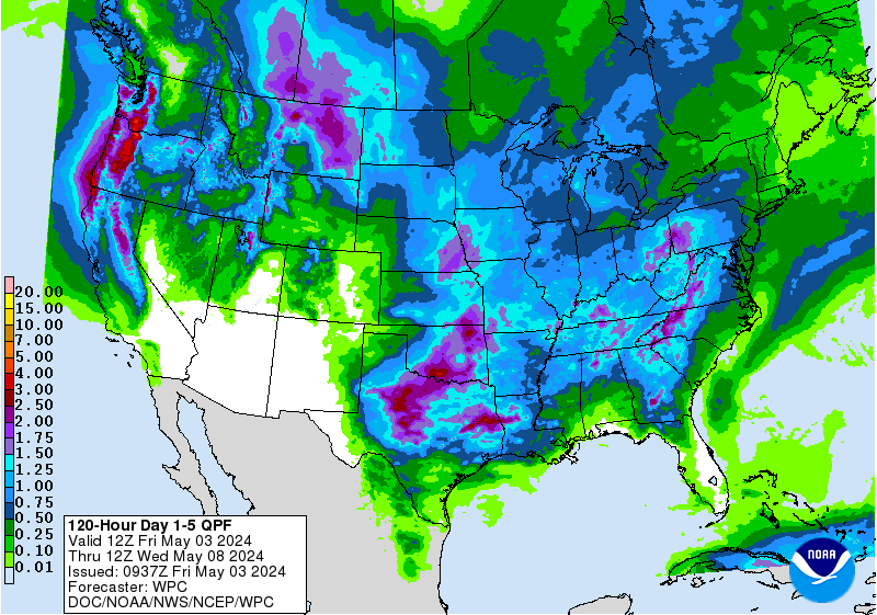
Here is the 5-day precipitation forecast, according to the NWS, with amounts in Illinois ranging from 0.5 to 1.5 inches. These are the potential amounts – your mileage may vary. The 7-day precipitation forecast shows much larger totals but I take less stock in precipitation amounts that far out.
The NWS 6-10 day forecast does show that Illinois has an increased chance of above-normal rainfall (green) during that time …

However, the NWS 8-14 day forecast shows Illinois with an increased chance of having below-normal rainfall (shaded in brown). The good news is that the indications are that Illinois may dodge the really hot weather with highs staying below 95 degrees over the next 14 days.

One Reply to “Dryness Across Illinois”