
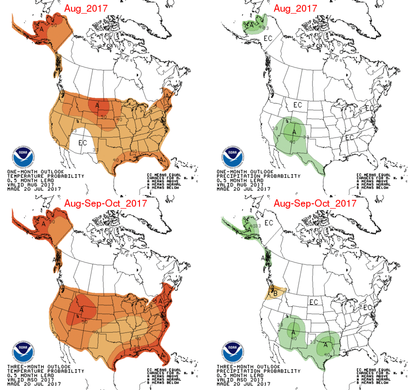
The NWS Climate Prediction Center just released their new outlooks (map below). For August, they indicated that Illinois has an increased chance of being warmer than normal (upper left panel). The same is true for the 3-month period of August-October (lower left panel). They have nothing to say about precipitation in Illinois – equal chances of above, below, or near-normal precipitation.
The NWS outlooks have pushed the increased chance of above-normal temperatures for 2017 in Illinois. They are doing well – January, February, March, April, and June have been above normal. Only May was slightly cooler than normal. So far in July, the statewide average temperature is 76 degrees, which is normal for this time of year.
Rainfall Extremes in Illinois in Last 30 Days
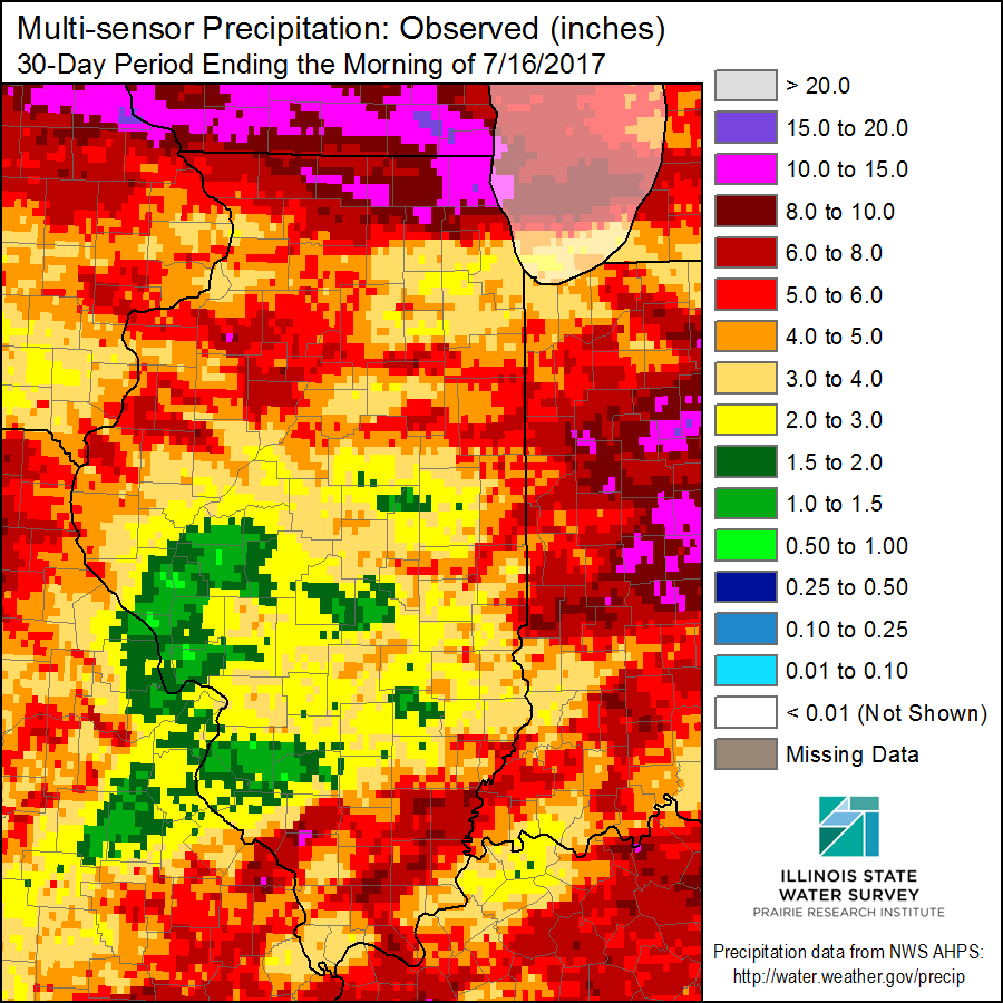
It is fairly typical of summer in Illinois to have areas with too much rain and other areas with not enough. However, the last 30 days have been extremely variable across the state. In the figure below of radar/rain-gage measured precipitation, we see amounts of 10 to 15 inches in Lake County (pink). In many other areas, we see shades of red which represent amounts between 4 and 10 inches. However, interlaced with those wet areas are areas with only 2 to 4 inches. And there are a few areas, especially around St. Louis that have had only 0.5 to 2 inches of rain (shades of green) in the last 30 days.
As you can imagine, areas in northern Illinois are struggling with flood conditions while areas in green are struggling with drought. There are reports of corn “firing” in Jersey and St. Clair Counties according to the Illinois Farm Bureau’s CropWatchers.
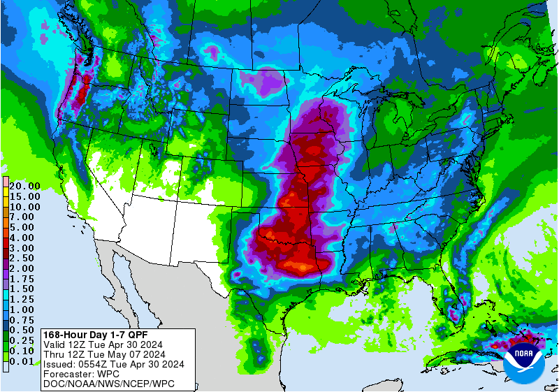
The recent NWS 7-day precipitation forecast doesn’t look promising with most of the rain expected to fall in northern Illinois (1 to 4 inches) where it is not needed. Meanwhile, the southern half of Illinois is expected to receive less than half an inch. We will see how this plays out.
Dryness Across Illinois
While heavy rains have fallen along the edges of Illinois, most of the state has received below normal rainfall over the last 30 days. Current soil moisture conditions and the NWS forecasts are reviewed below. In general, areas that missed out on rains in the last 30 days could be in for a rough ride in July.
Here is the map with the percent of normal rainfall for the last 30-days: areas in green and blue are above normal while areas in beige and brown are below normal. Several areas in central and southern Illinois have had less than 50 percent of their normal 4 or so inches. Continue reading “Dryness Across Illinois”
June – warm with rainfall extremes across Illinois
According to preliminary numbers, the statewide average temperature for June was 72.8 degrees, 0.9 degrees above normal. The statewide average rainfall was 3.27 inches, just 0.9 inches below normal.
June had a split personality. In the first 14 days, temperatures were nearly 4 degrees above normal with only a quarter inch of rain on average across the state. In the last 16 day, the temperatures were almost 2 degrees below normal with 3.0 inches of rain.
Here are the high-resolution maps showing the monthly totals. The rain in June was uneven with amounts of 5 to 10 inches along the Illinois-Wisconsin border, and around Quincy, Iroquois County, and in far southern Illinois. The rest of the state was much drier with only 2 to 4 inches of rain. A stretch between Havana and Champaign had received only 2 inches of rain. The station reporting the most rain in June was Belvidere (Boone County)with 12.08 inches. On the other extreme, White Heath (Piatt County) reported only 0.65 inches with no missing reports.

Continue reading “June – warm with rainfall extremes across Illinois”