

As predicted, heavy rains have fallen across much of Illinois in the last 7 days. The first round came on Wednesday and Thursday of last week, followed by another round starting Friday night and tapering off Sunday night.
The largest total for the last 7 days, as of Monday morning, was 12.03 inches at Carbondale. Five other stations reported amounts in the 8-inch range: Kaskaskia with 8.96 inches, Steeleville with 8.66 inches, Murphysboro with 8.60 inches, Chester with 8.23 inches, and Flora with 8.15 inches. A more extensive list is at the bottom of this post.
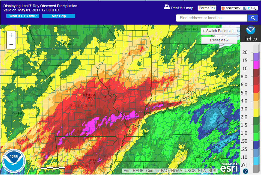
Here is the radar/rain gage product for the last 7 days. As confirmed by the rainfall reports, the heaviest rains fell in southern Illinois. The area around Carbondale received between 10 and 15 inches. Areas in the shades of red were between 5 and 10 inches. Meanwhile, the northern half of Illinois got off a little easier with amounts of 2 to 4 inches.
Not the greatest map in the world, but this NWS product shows several river gages in Illinois at some level of flood stage – orange means minor flooding, red means moderate flooding, and purple means major flooding. You can find the interactive version of this map here and click on the tab for “river observations”. Most locations on the Illinois and Mississippi River are showing at least minor flooding.

While the NWS map shows the stream flows as related to flood level, this map from the USGS shows the same stream flows relative to their historical record for this time of year. All the stations in blue have exceeded the 90th percentile, meaning that the flows are higher than 90 percent of the historical record. The stations in black are at record heights for this time of year. In case you are wondering, the USGS collects and archives the historical stream flow data while the NWS uses that information and produce forecasts of future conditions since they already produce the rainfall forecasts.

Generally, smaller rivers and streams react quickly to heavy rainfall, while it takes a while for the water to make its way into the large rivers. For example, the Illinois River at Hardin is at minor flood stage and rising. It is forecasted to peak at 33.3 feet Tuesday night.

Here are the precipitation totals over the last 7 days, courtesy of the Midwestern Regional Climate Center. I filtered out those sites with more than 2 days of missing data.
| Station Name | County | Precip | Percent Data |
| CARBONDALE SEWAGE PLT | Jackson County | 12.03 | 100 |
| KASKASKIA RIV NAV LO | Randolph County | 8.96 | 88 |
| MURPHYSBORO 2 SW | Jackson County | 8.60 | 88 |
| CHESTER | Randolph County | 8.23 | 88 |
| FLORA | Clay County | 8.15 | 100 |
| PINCKNEYVILLE 2 N | Perry County | 7.60 | 88 |
| EDWARDSVILLE 2 W | Madison County | 6.94 | 88 |
| RAMSEY | Fayette County | 6.87 | 100 |
| ALTON MELVIN PRICE | Madison County | 6.85 | 75 |
| RED BUD 5 SE | Randolph County | 6.84 | 88 |
| NEWTON | Jasper County | 6.78 | 88 |
| MT VERNON 3 NE | Jefferson County | 6.66 | 88 |
| HIGHLAND | Madison County | 6.64 | 100 |
| JERSEYVILLE 2 SW | Jersey County | 6.54 | 88 |
| CARMI 2 | White County | 6.50 | 88 |
| CASEY | Clark County | 6.43 | 100 |
| NASHVILLE 1 E | Washington County | 6.39 | 88 |
| PITTSFIELD #2 | Pike County | 6.38 | 100 |
| IUKA | Marion County | 6.24 | 88 |
| CHARLESTON | Coles County | 6.16 | 88 |
| PLUMFIELD | Franklin County | 5.98 | 75 |
| HARDIN | Calhoun County | 5.96 | 88 |
| CENTRALIA | Clinton County | 5.94 | 88 |
| CLAY CITY 6SSE | Clay County | 5.91 | 100 |
| MEDORA | Macoupin County | 5.89 | 100 |
| NEOGA | Cumberland County | 5.87 | 88 |
| NEOGA 4NW | Shelby County | 5.69 | 88 |
| GRAFTON | Jersey County | 5.53 | 88 |
| VIRGINIA | Cass County | 5.52 | 100 |
| WHITE HALL 1 E | Greene County | 5.51 | 75 |
| BEECHER CITY | Effingham County | 5.32 | 88 |
| CARLYLE RSVR | Clinton County | 5.24 | 88 |
| MT OLIVE 1 E | Macoupin County | 5.17 | 88 |
| JACKSONVILLE 2 | Morgan County | 5.15 | 100 |
| BROOKPORT DAM 52 | Massac County | 5.14 | 100 |
| BELLEVILLE SCOTT AFB | Saint Clair County | 5.13 | 75 |
| OTTAWA | La Salle County | 5.12 | 75 |
| ROMEOVILLE LEWIS UNIV AP | Will County | 5.11 | 100 |
| SHELBYVILLE DAM | Shelby County | 5.10 | 88 |
| PANA | Christian County | 5.08 | 100 |
| MATTOON | Coles County | 5.00 | 88 |
| MT VERNON OUTLAND AP | Jefferson County | 5.00 | 88 |
| EFFINGHAM | Effingham County | 4.98 | 100 |
| PARIS STP | Edgar County | 4.98 | 100 |
| VANDALIA | Fayette County | 4.97 | 88 |
| PEORIA INTL AP | Peoria County | 4.93 | 88 |
| HAVANA | Mason County | 4.87 | 88 |
| SEVILLE | Fulton County | 4.82 | 88 |
| QUINCY RGNL AP | Adams County | 4.81 | 88 |
| GREENVILLE | Bond County | 4.80 | 75 |
| ROSICLARE 5 NW | Hardin County | 4.79 | 100 |
| AURORA | Kane County | 4.76 | 100 |
| EFFINGHAM SE | Effingham County | 4.73 | 88 |
| MARSEILLES LOCK | La Salle County | 4.63 | 100 |
| TUSCOLA | Douglas County | 4.56 | 100 |
| AUGUSTA | Hancock County | 4.55 | 100 |
| JOLIET BRANDON RD DM | Will County | 4.54 | 100 |
| GRAND CHAIN DAM 53 | Pulaski County | 4.54 | 100 |
| WINDSOR | Shelby County | 4.48 | 100 |
| SIDELL 4N | Vermilion County | 4.43 | 100 |
| SPRINGFIELD #2 | Sangamon County | 4.33 | 100 |
| PEORIA 5NW | Peoria County | 4.32 | 88 |
| MINONK | Woodford County | 4.30 | 88 |
| KINCAID | Christian County | 4.26 | 100 |
| CANTON | Fulton County | 4.22 | 100 |
| SHELBYVILLE 5W | Shelby County | 4.20 | 88 |
| MORRIS 1 NW | Grundy County | 4.16 | 88 |
| SPRINGFIELD ABRAHAM LINCOLN CA | Sangamon County | 4.13 | 88 |
| EFFINGHAM CO MEM AP | Effingham County | 4.11 | 88 |
| YATES CITY | Knox County | 4.09 | 88 |
| STREATOR | Livingston County | 4.09 | 88 |
| LITTLE RED SCHOOL HSE | Cook County | 4.08 | 100 |
| BENTLEY | Hancock County | 3.99 | 100 |
| MORTON | Tazewell County | 3.98 | 100 |
| LISLE-MORTON ARBORETUM | DuPage County | 3.97 | 100 |
| EARLVILLE 3S | La Salle County | 3.96 | 100 |
| HENNEPIN | Putnam County | 3.92 | 88 |
| BUFFALO | Sangamon County | 3.91 | 100 |
| LAKE SPRINGFIELD | Sangamon County | 3.90 | 100 |
| CHICAGO MIDWAY AP 3 SW | Cook County | 3.90 | 88 |
| WAYNE CITY 1 N | Wayne County | 3.88 | 88 |
| ELGIN | Kane County | 3.85 | 100 |
| RIPLEY | Brown County | 3.85 | 88 |
| OAKFORD RIVER | Vermilion County | 3.84 | 88 |
| MOWEAQUA 2S | Shelby County | 3.83 | 88 |
| MT PULASKI | Logan County | 3.81 | 100 |
| OGDEN | Champaign County | 3.81 | 100 |
| MACKINAW 1N | Tazewell County | 3.76 | 100 |
| KEWANEE 1 E | Henry County | 3.73 | 100 |
| MENDOTA 2 SE | La Salle County | 3.70 | 100 |
| PRAIRIE CITY 2S | McDonough County | 3.69 | 100 |
| ATHENS 4SW | Menard County | 3.69 | 88 |
| DUPAGE AIRPORT | DuPage County | 3.67 | 88 |
| CHICAGO OHARE INTL AP | Cook County | 3.63 | 88 |
| QUINCY DAM 21 | Adams County | 3.62 | 100 |
| LOVINGTON | Moultrie County | 3.57 | 100 |
| YORKVILLE 2SE | Kendall County | 3.56 | 88 |
| ROCHELLE | Ogle County | 3.55 | 100 |
| PHILO | Champaign County | 3.55 | 88 |
| PRINCETON | Bureau County | 3.53 | 100 |
| ELBURN | Kane County | 3.46 | 100 |
| DECATUR WTP | Macon County | 3.42 | 88 |
| EUREKA | Woodford County | 3.41 | 88 |
| ROANOKE | Woodford County | 3.37 | 88 |
| MUNDELEIN 4 WSW | Lake County | 3.35 | 100 |
| MACOMB | McDonough County | 3.32 | 88 |
| CHICAGO MIDWAY AP | Cook County | 3.3 | 88 |
| LINCOLN | Logan County | 3.29 | 88 |
| PEORIA | Peoria County | 3.29 | 88 |
| LA HARPE | Hancock County | 3.24 | 100 |
| BEARDSTOWN | Cass County | 3.22 | 75 |
| DIXON 1W | Lee County | 3.18 | 100 |
| PAW PAW 2S | Lee County | 3.18 | 100 |
| NORMAL 4NE | McLean County | 3.18 | 100 |
| PLAINFIELD 3 NE | Will County | 3.18 | 88 |
| NEW BOSTON DAM 17 | Mercer County | 3.17 | 100 |
| DE KALB | DeKalb County | 3.14 | 100 |
| ALTONA | Knox County | 3.13 | 88 |
| GENOA 2SW | DeKalb County | 3.07 | 100 |
| RANTOUL | Champaign County | 3.06 | 88 |
| CAIRO RIVER | Alexander County | 3.06 | 88 |
| STEWARD 3S | Lee County | 3.04 | 100 |
| ROCKFORD GTR ROCKFORD AP | Winnebago County | 3.02 | 88 |
| ROSCOE 2 SE | Winnebago County | 2.99 | 100 |
| LEONORE 3 NE RIVER | La Salle County | 2.99 | 88 |
| GLEN ELLYN 4 S | DuPage County | 2.98 | 88 |
| PARK FOREST | Cook County | 2.96 | 100 |
| JOLIET | Will County | 2.93 | 88 |
| WILMINGTON 4 NW RIVER | Will County | 2.93 | 88 |
| GALESBURG | Knox County | 2.91 | 100 |
| AVON | Fulton County | 2.90 | 100 |
| GENESEO | Henry County | 2.90 | 88 |
| CISCO | Piatt County | 2.90 | 88 |
| SALEM | Marion County | 2.90 | 75 |
| MT CARMEL | Wabash County | 2.88 | 75 |
| GLADSTONE DAM 18 | Henderson County | 2.82 | 88 |
| CONGERVILLE 2NW | Woodford County | 2.80 | 88 |
| CHAMPAIGN 9 SW | Champaign County | 2.76 | 88 |
| PAXTON | Ford County | 2.75 | 100 |
| SHABBONA 5 NNE | DeKalb County | 2.75 | 88 |
| CAIRO RGNL AP | Alexander County | 2.73 | 88 |
| LONDON MILLS 1 SW | Fulton County | 2.71 | 88 |
| OLNEY 2S | Richland County | 2.69 | 75 |
| ALEDO | Mercer County | 2.67 | 100 |
| KNOXVILLE | Knox County | 2.64 | 88 |
| LOCKPORT PWR HOUSE | Will County | 2.61 | 88 |
| ROCK ISLAND L&D 15 | Rock Island County | 2.6 | 88 |
| UTICA STARVED ROCK D | La Salle County | 2.6 | 75 |
| WARRENVILLE RIVER | DuPage County | 2.55 | 88 |
| ST CHARLES 2NW RIVER | Kane County | 2.5 | 88 |
| MOLINE QUAD CITY INTL AP | Rock Island County | 2.43 | 88 |
| BLOOMINGTON WTR WKS | McLean County | 2.41 | 88 |
| FREEPORT WWP | Stephenson County | 2.39 | 100 |
| GENESEO 2 N | Henry County | 2.28 | 88 |
| MANHATTAN 5 NE | Will County | 2.26 | 88 |
| JOSLIN | Rock Island County | 2.25 | 88 |
| DWIGHT | Livingston County | 2.21 | 88 |
| CHICAGO BOTANICAL GARDEN | Cook County | 2.16 | 88 |
| ILLINOIS CITY DAM 16 | Rock Island County | 2.14 | 100 |
| BOURBONNAIS 3NW | Kankakee County | 2.11 | 100 |
| BARRINGTON 3 SW | Cook County | 2.1 | 88 |
| MARENGO | McHenry County | 2.09 | 88 |
| KEITHSBURG | Mercer County | 2.05 | 88 |
| FAIRBURY WWTP | Livingston County | 1.94 | 100 |
| ELIZABETH | Jo Daviess County | 1.91 | 100 |
| LANSING | Cook County | 1.90 | 88 |
| FULTON DAM | Whiteside County | 1.83 | 75 |
| CHATSWORTH | Livingston County | 1.75 | 100 |
| ROCKTON RIVER | Winnebago County | 1.72 | 88 |
| CHAMPAIGN 3S | Champaign County | 1.71 | 88 |
| MONEE RSVR | Will County | 1.68 | 88 |
| GURNEE 3 SW RIVER | Lake County | 1.67 | 88 |
| RUSSELL RIVER | Lake County | 1.64 | 88 |
| GALENA | Jo Daviess County | 1.59 | 88 |
| STOCKTON 3 NNE | Jo Daviess County | 1.57 | 88 |
| WOODSTOCK 5 NW | McHenry County | 1.54 | 88 |
| PONTIAC | Livingston County | 1.41 | 88 |
| MOMENCE 5ENE | Kankakee County | 1.23 | 88 |
| ST ANNE | Kankakee County | 1.17 | 88 |
| CLINTON 1SSW | De Witt County | 1.00 | 75 |