

As of April 25, the statewide average precipitation for Illinois is 2.8 inches, which is 94% of normal. However, we have several opportunities for widespread rains this week and into the weekend, according to the NWS precipitation forecast.
The first round of rain on Wednesday and Thursday has potential rainfall amounts of 1 to 2 inches across most of Illinois, along with the chance for severe weather.

There is a risk of severe weather along with this system.

From the NWS Storm Prediction Center
...Illinois into the Great Lakes...
   Instability and low-level moisture will be less in this region
   compared to farther south but sufficient for an organized severe
   threat given favorable wind profiles. The stronger storms will
   likely expand into this region during the late afternoon and
   evening, with a few supercells and bowing linear segments capable of
   damaging wind, large hail and a couple of tornadoes.
The second round of rain over the weekend has potential rainfall amounts of 2 to 5 inches in the southern half of Illinois and 1 to 2 inches elsewhere in the state. Keep in mind that this rain will be falling on soils already saturated from the mid-week rains, raising the potential for flooding. The cutoff for this map is Sunday morning and more rain is expected later in the day.

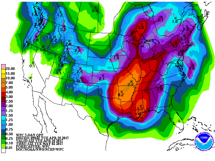
Put that all together and we are faced with the potential for widespread heavy rains over the next 7 days, ranging from 2.5 inches in northwest Illinois to almost 7 inches in southwestern Illinois (below).
Here is what the NWS office in Lincoln IL says about the situation.
Hydrologic Outlook
National Weather Service Lincoln IL
539 AM CDT Tue Apr 25 2017
...AREAS OF HEAVY RAIN ON WEDNESDAY AND AGAIN THIS WEEKEND...
A wet weather pattern will set up through mid week, and persist
into the upcoming weekend.
As a cold front approaches from the west, showers and
thunderstorms will begin spreading into areas west of I-55 later
tonight, and overspread areas to the east on Wednesday, before
exiting the region on Thursday. The heaviest rain from this system
is expected to be from about I-55 westward, where amounts of 1 to
1.5 inches are possible by Thursday morning. Over east central and
southeast Illinois, rainfall of a half to 1 inch is likely.
This weekend, a slow moving storm system will combine with copious
moisture in the atmosphere, to produce additional heavy rainfall.
Much of this is expected between late Friday night and Sunday
morning. While it is too early to give specifics, there are
indications that a few inches of rain are possible during the
period over portions of central and southeast Illinois.
Runoff from this heavy rain will cause rises on area rivers and
streams, and may eventually lead to flooding. Continue to monitor
the latest forecasts, as the rainfall timing and amounts will be
adjusted as the heavy rain events approach.
$$
Geelhart
Historically, the statewide average April temperature in Illinois has increased by 2 degrees over the past century. April precipitation has increased by about 25 percent over the past century.