

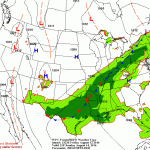
One thing I love about the weather of Illinois it that it’s always changing. I was just getting ready to write a blog post about how dry it was getting in eastern Illinois. However, I soon realized that the dryness was the least of our worries right now. The NWS precipitation forecast for the next 5 days shows widespread, heavy rainfall across Illinois. The potential rainfall totals are smallest in the north and get progressively larger moving south. The potential totals are 1.5 to 3 inches in northern IL, 3 to 7 inches in central IL, and 7 to 10 inches in southern IL. The National Weather Service has issued Flash Flood Watches for northeast and southern Illinois.

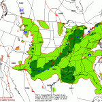
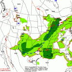
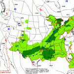
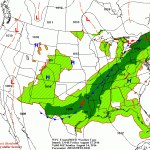
The reason for all this rain is that a cold front is moving slowly across the state, with plenty of warm, moist air ahead of it to feed the rainfall. Here are the forecast maps for Friday evening through Sunday morning. Areas in light green have a chance of rain, areas in dark green are very likely to have rain. More rain is in store for Monday and Tuesday. Click to enlarge.
Before the weekend: here was how the rainfall looked across Illinois for August before the rains started on Friday. Areas in the west and south received 1 to 3 inches, with amounts of 3 to 5 inches near the Quad Cities. Meanwhile, eastern Illinois was dry with less than a tenth of an inch in many locations, including Champaign-Urbana with 0.0 inches for the month.
