February Weather So Far in Illinois

For the first 14 days of February, temperatures have been slightly warmer than average (0.9 degrees above average). However, there was a stark contrast between the first two weeks. Champaign-Urbana was typical of the state with the first 7 days running 10.5 degrees above average and the next 7 days running 9.9 degrees below average.

Meanwhile, precipitation through the morning of February 15 has been widespread with amount of 0.5 to 1.5 inches common, and generally below-average in the southern half of the state. Snowfall has been widespread this month, but close to average in amounts. Monthly totals to date of 2 to 5 inches were common.


map1
Precipitation (rain plus water content of snow)


map2
Precipitation Departure from Average. Yellow means below-average, green means above-average. 
map3
Snowfall. 

2016 Midwest Warmer and Drier Than Average

Despite a few cold and snowy days, the Midwest was been both warmer and drier than average for 2016. As this map shows, most of the Midwest has has seen less than 2 inches of precipitation since January 1. That includes any rainfall plus the water content of snowfall. Areas in orange have received 1 to 2 inches, and areas in red have received less than an inch.

map1

However, this is the driest time of the year for most of the Midwest. As a result, precipitation is slightly above average in a swath across Iowa, Wisconsin, and Michigan, thanks to several winter storms. However, the southern half of the Midwest is down 1 to 3 inches. Of course, this same area received much-above-average precipitation in December thanks to the late December storm. As a result, the drier weather may be welcome news for many in that area.

map2

Despite a few days of cold weather in recent weeks and the chilly forecast for this weekend, temperatures since January 1 have been running above average across the Midwest. This map shows the temperature departures for 2016. Minnesota, Wisconsin, and Michigan, as well as northern Indiana and Ohio, are running 2 to 4 degrees above average. The rest of the Midwest is running up to 2 degrees above average. Meanwhile, colder-than-average conditions have prevailed in Kentucky and Tennessee.

map3

January – Wild Temperature Swings and Dry

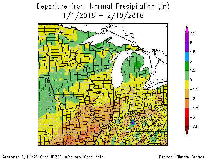
Summary: January in Illinois finished out at 26.7 degrees, 0.3 degrees above average. Both precipitation and snowfall were below average. The statewide average precipitation (rain plus water content of snow) was 0.85 inches, 1.22 inches below average. Snowfall was below average across most of the state.

Temperature

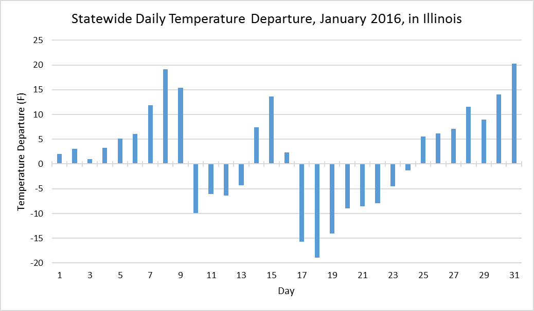
The temperatures in January in Illinois showed some very large swings that tended to cancel each other out in the end since we finished 0.3 degrees above average. The first 9 days were above average, followed by 4 days below average, then 3 days above average. The second half of January started out much below average, but steadily warmed and by the end of the month was 20 degrees above average.

While the magnitude of the swings were impressive, the pattern of warm and cold stretches is typical of winter in Illinois and represents the passage of warm and cold fronts across the region. Because it may take a day or more for a system to pass through Illinois, the dates and size of the temperature departures at a particular station may not correspond to the statewide numbers, especially in far southern Illinois.

image001

Precipitation

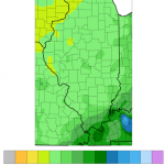
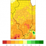
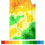
The January precipitation (left) and departures from average (right) show that precipitation was uniformly light across Illinois, just under an inch in most places (light green) and just over an inch below average (shades of yellow).

Snowfall

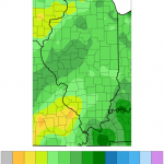
The January snowfall (left) ranged from 2 to 5 inches in most locations. Western Illinois saw 5 to 7.5 inches. However, as the panel on the right indicates most of Illinois received below-average snowfall (shades of beige and yellows).