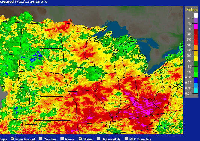
Here is the latest radar/raingauge estimated rainfall totals for July across the Midwest through this morning.
Much of the Corn Belt has been extremely wet. Heavy rains amounts of 5 to 10 inches are found across Minnesota, Wisconsin, Missouri, southern Iowa, Illinois, Indiana, Ohio, and Kentucky for July. Even portions of the Plains states received 2 to 5 inches of rain, which is well above their typically dry July.
For Illinois, amounts of 5 to 10 inches are found between East St. Louis, Moline, and eastward, as well as south of Carbondale and parts of northeast Illinois. Most of the rest of the state has received 2 to 5 inches. There are even a few small areas with less than 2 inches of rain in southern Illinois and the northwest corner.
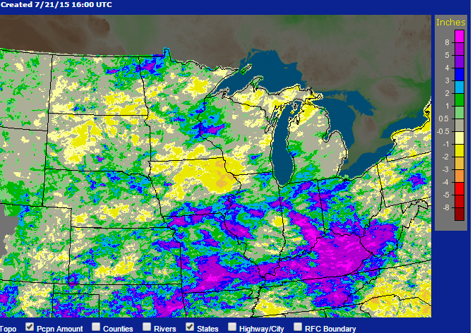
The map below shows the July rainfall as a departure from average. The areas in Illinois noted earlier with 5 to 10 inches are running 2 to 5 inches above average. The rest of the Illinois is running closer to average.
The shades of purple in Missouri, Indiana, Ohio, and Kentucky represent areas with 4 to 8 inches above average. The only “dry” spot in the Corn Belt is Iowa. Of course they had good rains back in June.
According to the NWS, Illinois should see a break in the wet pattern this week with less expected rain and more sunshine with daytime highs starting out in the upper 70s and low 80s today before warming into the low 90s by the end of the week.