Tropical Storm Bill’s Rainfall in Illinois

The remains of Tropical Storm Bill moved through Texas and Oklahoma and up through the Midwest. As a result, it produced quite a bit of rain in southern Illinois.

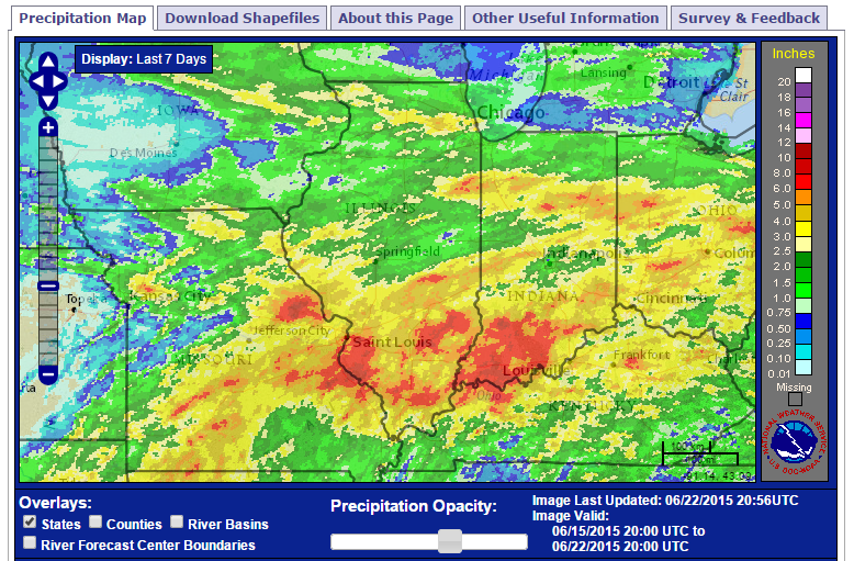
While it is difficult to separate out the rainfall exclusively from Tropical Storm Bill, this radar-estimated rainfall image of the past 7 days shows the pattern. Areas in yellow and red received at least 3 inches of rainfall. The widespread areas in red south of Interstate 70 received in the neighborhood of 6 to 8 inches of rain.

Missouri, Indiana, Ohio, and Kentucky received significant rainfall as well.

map3
Click to enlarge.

So Far, Fifth Wettest June on Record for Illinois

Even before today’s rain, the statewide average rainfall for June in Illinois is 7.11 inches. That makes it the 5th wettest June on record. And June is not over. Here are the top ten wettest June totals on record and where we stand:

  1. 1902 with 8.27 inches
  2. 2010 with 7.71 inches
  3. 1998 with 7.64 inches
  4. 2000 with 7.34 inches
  5. 2015 with 7.11 inches (as of 6/21/2015)
  6. 1928 with 6.93 inches
  7. 1993 with 6.85 inches
  8. 1924 with 6.80 inches
  9. 2014 with 6.77 inches
  10. 2011 with 6.69  inches

Notice anything unusual about that list? Five out of the 10 wettest June totals have occurred since 2000. Our statewide records go back to 1895.

map2
Click to enlarge.

Due to the heavy rains of June, we first saw flooding on the smaller rivers and streams in Illinois. Now the larger rivers are responding to the wet conditions. The NWS can keep you posted on the latest flooding issues at www.weather.gov

Above-Average Rainfall Expected for Rest of June and July in Illinois

The post from this morning documented the above-average rainfall received so far in June across Illinois. On top of that, the latest NWS forecasts indicate that wetter-than-average conditions are expected for the rest of June as well as July in Illinois.

The first map shows the 6-10 day forecast with Illinois and most of the Corn Belt having an increased chance of wetter-than-average conditions. The second map shows the 8-14 day forecast with the same wet pattern.

The third map shows the month of July with an increased chance of wetter-than-average conditions across all of Illinois. The fourth map shows the three-month forecast for July-September. At that point, the chance for wetter-than-average conditions is confined to western Illinois.

610prcp.new
6-10 Day Forecast. Areas in green have an increased chance of above-average precipitation. Click to enlarge.

Continue reading “Above-Average Rainfall Expected for Rest of June and July in Illinois”

June 2015 – Wet Across the Midwest

June 2015 has been wet across the Midwest and we still have 12 more days in the month. Wet conditions extend from Kansas/Nebraska and eastward through Missouri, Iowa, Illinois, Indiana, and Ohio. Amounts in those areas are in the 4 to 8 inch range.

Monthly totals from a few stations are in the 10 inch range, including 10.44 inches at Lacon, IL (north of Peoria) and 10.41 inches in Stockton, IL (in the northwest corner).

While this is very preliminary, the statewide average precipitation is 5.3 inches for June. The monthly average is 4.2 inches, so we would already have an above-average month if it stopped raining today. The record for June is 8.27 inches set in 1902.

Maps

Continue reading “June 2015 – Wet Across the Midwest”