Frost in Illinois – Not Quite Yet

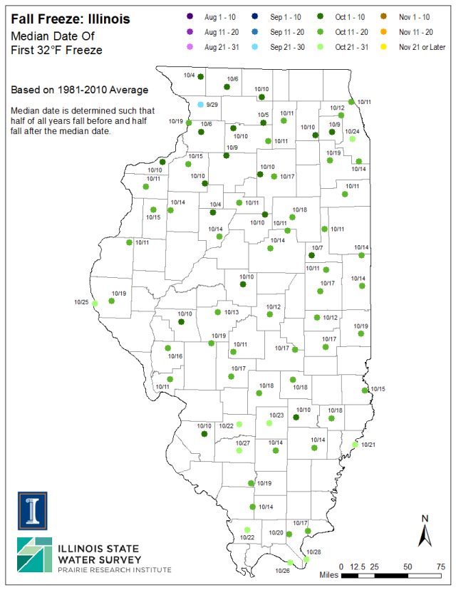
While cold air moved in behind the low-pressure system that passed through the Midwest this week, it looks like Illinois will likely dodge the freezing temperatures for now. But someday they will come. Here are the median dates for when we see the temperatures drop to 32 or below in fall, as well as the earliest date in 1 out of 10 years.

In general, we hit 32 degrees in early October for northern Illinois and mid October for central and southern Illinois. In 1 year in 10, we have seen 32 degrees in the last week of September (second map) or the first few days of October. See more maps and discussion of frost on the State Climatologist web site.

fall-freeze-32-median

Continue reading “Frost in Illinois – Not Quite Yet”

Heavy Rains in Western and Central Illinois

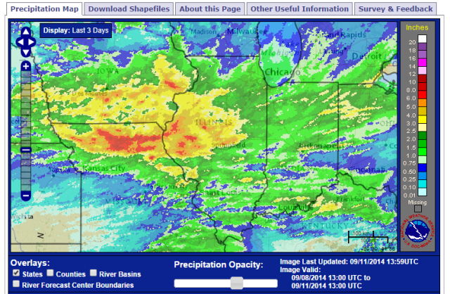
Heavy rains have fallen in western and central Illinois over the last three days. Here is the overall picture showing the heavy rains in southern Iowa and northern Missouri as well. Areas in yellow, orange, and red experienced 2.5 to 8 inches of rain. Much of the rest of Illinois received 1 to 2 inches.

www.srh.noaa.gov ridge2 RFC_Precip
3-day Rainfall Totals based on radar and rain gauge measurements. Click to enlarge. Source: http://www.srh.noaa.gov/ridge2/RFC_Precip/

The largest three-day total comes out of Rushville with 8.06 inches with most of that falling on one day (6.96 inches on September 10). To put that in perspective, the average September rainfall at Rushville is 3.65 inches. So this three-day period was over twice the average for the entire month. Continue reading “Heavy Rains in Western and Central Illinois”

Year to Date – Cool and Wet in Illinois

It is probably not shocking news to find out that the first 8 months of 2014 have been both cooler and wetter than average for Illinois.

The statewide average temperature for January-August was 50.8 degrees, 3.5 degrees below the 1981-2010 average and tied with 1924 as the fifth coolest on record.

The statewide average precipitation for January – August was 28.79 inches, 1.46 inches above average and the 34th wettest on record.

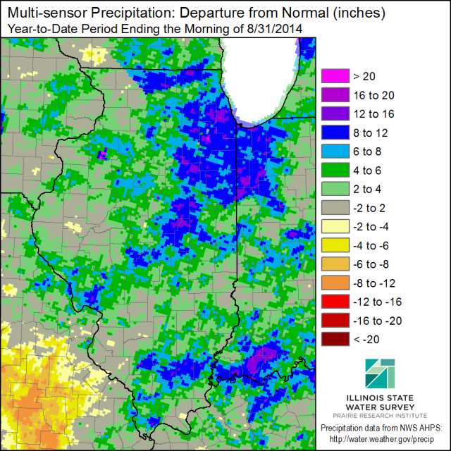
Here is what the precipitation departures look like through the end of August. Several areas in northeast and east-central Illinois have precipitation departures of 6 to 12 inches above average in the shades of blue, and a few areas with 12 to 16 inches above average. Areas in green are 2 to 6 inches above average. Only a few small areas in tan/beige are 2 to 4 inches below average.

IL-prcp-mpe-y2d-dev-20140831

Summer Weather Gives Way to Fall

If you look at the start to September, temperatures have run 3 degrees above average. And yesterday and today have been the hottest yet with temperatures the 80s and 90s across much of state. But that is about to change as a cold front pushes through later today. This weekend and next week will be cooler with highs in the 70s and low 80s.  I am looking forward to that.

Average daily highs in September in Illinois range from the low to mid 70s in northern Illinois to the low 80s in southern Illinois (map below, click to enlarge).

Illinois-tmax-09SEP-normals

Continue reading “Summer Weather Gives Way to Fall”