Washington IL – 4 Months After the November 17 Tornado

2014-03-21photo1
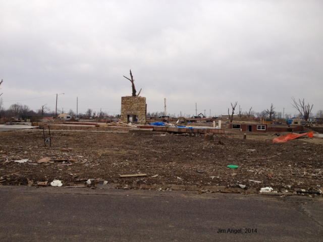
The first thing you notice is the fireplace standing alone. If you click to enlarge the photo, you can clearly see debris that had been buried under snow all winter. You can see other damaged houses in the background as well as the ruined trees.

On Friday, I visited Washington IL to check on the recovery from the November 17, 2013, tornado event. The good news is that I saw lots of construction. The bad news is that a lot of damage remains. As a result of the harsh winter, very little clean up could be done in these conditions, let alone extensive construction. In fact, the city is still looking for volunteers to help with the cleanup. Other locations hit by the November 17 tornado outbreak are facing similar conditions.

While tornadoes can occur in any month of the year, our core season in March-June. In many cases, a community has a full construction season to recover from such a disaster. One of the unique aspects of this tornado outbreak is that it happened in mid November, with winter right around the corner. And not just any winter, but one of the harshest winters in a long time. Looking at the weather records for nearby Peoria, the low temperatures after November 17 quickly dropped below freezing with a few light snow events. By December, they had a full-blown winter. By the end of it, Peoria received 49.6 inches of snow, the second highest total behind the 52.5 inches in 2010-11. It was the 8th coldest December-February on record as well. It is no wonder that the cleanup effort has a long ways to go.

However, as they say, “spring brings hope” and on that spring day last Friday I saw signs of hope and recovery for Washington IL. My sympathies go out to all tornado victims as they heal physically, financially, and emotionally from this natural disaster.

2014-03-21photo2
Here is an example of a concrete slab wiped clean in the foreground and new houses under construction in the background. Friday was a nice day and the builders were running at 100%. Click to enlarge.
2014-03-21photo3
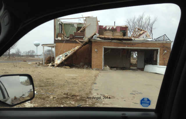
This house has been severely damaged with the loss of the roof and most of the upstairs walls. What I found haunting is that you can clearly to two twin beds on the right, another bedroom on the left. While it did not come out in the photo, there were clothes still hanging in the closet. Click to enlarge.
2014-03-21photo4
Another severely damaged house with the roof and several walls missing. By the front door is a piece of plywood with the words “OK” on it; hopefully indicating that the residents survived. Click to enlarge.

New NOAA Climate and Flood Outlooks

Happy Spring Equinox!

Seasonal Temperature and Precipitation Outlooks

There were a lot of new outlooks released today from NOAA. First are the new temperature and precipitation outlooks for April and this spring. It looks like the below-average temperatures are likely to continue in April. We have had below-average temperatures in Illinois for every month since November.

The April-June outlook has northern Illinois with an increased chance of below-average temperatures. Areas labeled E.C. mean that there are equal chances of above-, below-, or near-average temperatures or precipitation (depending on the map type).

page2
NWS Climate Prediction Center outlooks. Click to enlarge.

Spring Flooding Risk

The second major announcement is the spring flood outlook.

sfo_full

In the article, they say,

An unusually cold and wet winter across the Upper Mississippi Basin, Great Lakes region, Ohio River Valley, northern Middle Atlantic, New York and New England has produced an above normal amount of water in the current snowpack and a deep layer of frozen ground much further south than typical. With significant frozen ground in these areas, the flood risk is highly dependent on the amount of future rainfall and the rate of snowmelt this spring. Recent snowmelt has increased the near surface soil moisture and elevated the potential for rapid runoff from rain events. In addition, significant river ice increases the risk of flooding related to ice jams and ice jam breakups.

Moderate flooding is expected in southern Wisconsin, southern Michigan and portions of Iowa, Illinois and Indiana, as a result of water in the current snowpack and the deep layer of frozen ground coupled with expected seasonal temperatures and rainfall. Specific rivers at risk include the Mississippi River between Davenport, Iowa and Burlington, Iowa, the Illinois River between Beardstown, Illinois and Henry, Illinois and many smaller rivers in the area. In addition, a potential for exceeding minor river flood levels exists across the upper Midwest and east into New England.

First Half of March – Cold and Dry

Winter’s grip on Illinois is slowly releasing. However, we remain cold and dry for March. The statewide average temperature for March 1-16, 2014, was 30.3 degrees, which is almost 8 degrees below average. The good news is that the average, or normal, temperatures are climbing rapidly through the month. As a result, being 8 degrees below average in mid-March is still warmer than this winter. The NWS Climate Prediction Center 6-10 and 8-14 day forecasts show the below-average temperatures to continue through the end of March.

Besides the cooler temperatures, another concern at this point is the below-average precipitation (in shades of yellow and orange) for March so far. This is true not only across Illinois but much of the Midwest.

MonthPDeptMRCC
March Precipitation Departure from Average (inches). Click to enlarge.

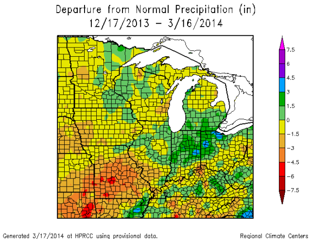
Below are the 90-day precipitation departures from average. Above-average precipitation (shaded in green) can be found in IL, IN, OH, and MI, due for the most part to our generous snows and a few rain events. However, parts of southeastern IL are 1.5 to 3 inches below average. This is part of a larger area of dryness covering Missouri and parts of KS, OK, and AR. Of course this pattern could change quickly as we get out of winter and into spring. A few good spring rains could erase most of this deficit. In the meantime, we will be watching this area closely.

90dPDeptMRCC

4th Coldest Winter in Illinois and What Follows

I have received several questions about whether or not this winter is an indicator of the upcoming growing season. The good news is that, at least historically, a harsh winter is not followed by a harsh summer.

Analysis

The statewide average temperature for the three core winter months of December, January, and February was 20.8 degrees. That was 8.2 degrees below average and the fourth coldest December-February period on record. Here is how it compared with some other cold winters in Illinois.

Rank Year Avg.
1 1977-1978 19.6
2 1978-1979 19.9
3 1935-1936 20.6
4 1917-1918 20.8
4 1976-1977 20.8
4 2013-2014 20.8

By the way, the 1981-2010 statewide average is 29.0 degrees.

So what followed after these harsh winters? We will look at the winters of the late 1970s first. The plot below shows the monthly temperature departures from average for Illinois. After the first of the three harsh winters, we had a remarkably warm spring in 1977, followed by summer and fall temperatures close to average. The temperatures in 1978 and 1979 were even closer to average. Not shown here, but the precipitation during the growing season of those three years was close to average as well. Overall, the growing seasons were unremarkable in both temperature and precipitation.

image001

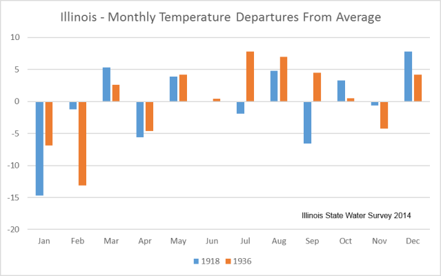
Here is the same analysis (plot below) for the two other harsh winters in the list: 1918 and 1936. The interesting thing about 1918 as the persistent alternation between warmer- and colder-than-average conditions from one month to the next. Precipitation for 1918 was one inch below average. Of course, 1936 is infamous for both the drought and heat that summer. That is clearly seen in the July, August, and September temperatures on the graph.

So of the five harsh winters in the analysis, we have only one case of a following summer showing harsh conditions. Another analysis I did offline with winter and summer temperatures showed zero correlation between the two.

image003