Based on preliminary reports, six people were killed in Harrisburg (southeastern Illinois), when a tornado struck late last night. The NWS is surveying the damage today. I will post more information when it becomes available.
Update 9:30 pm, March 1. I have updated the numbers below to reflect the addition of 2011 data.
Update 8:30 am, March 1. The Paducah NWS office has released a preliminary report on the tornado outbreak in southern Illinois, Indiana, and Kentucky.
Update 3:45 pm, February 29. According to a news conference aired on WSIL-TV, the NWS has identified this as an EF-4 tornado with wind speeds up to 170 mph. Wind speeds are estimated from the level of devastation at the scene in Harrisburg. EF-4 tornadoes are relatively rare in Illinois. Out of 2244 2322 tornadoes reported in Illinois between 1950 and 2010 2011, only 40 were in this category. However, they are very deadly. Of the 203 deaths related from tornadoes between 1950-20102011, 100 of these came from EF-4 tornadoes. That is 49 percent of the data with an average rate of 2.5 deaths per EF-4 event.
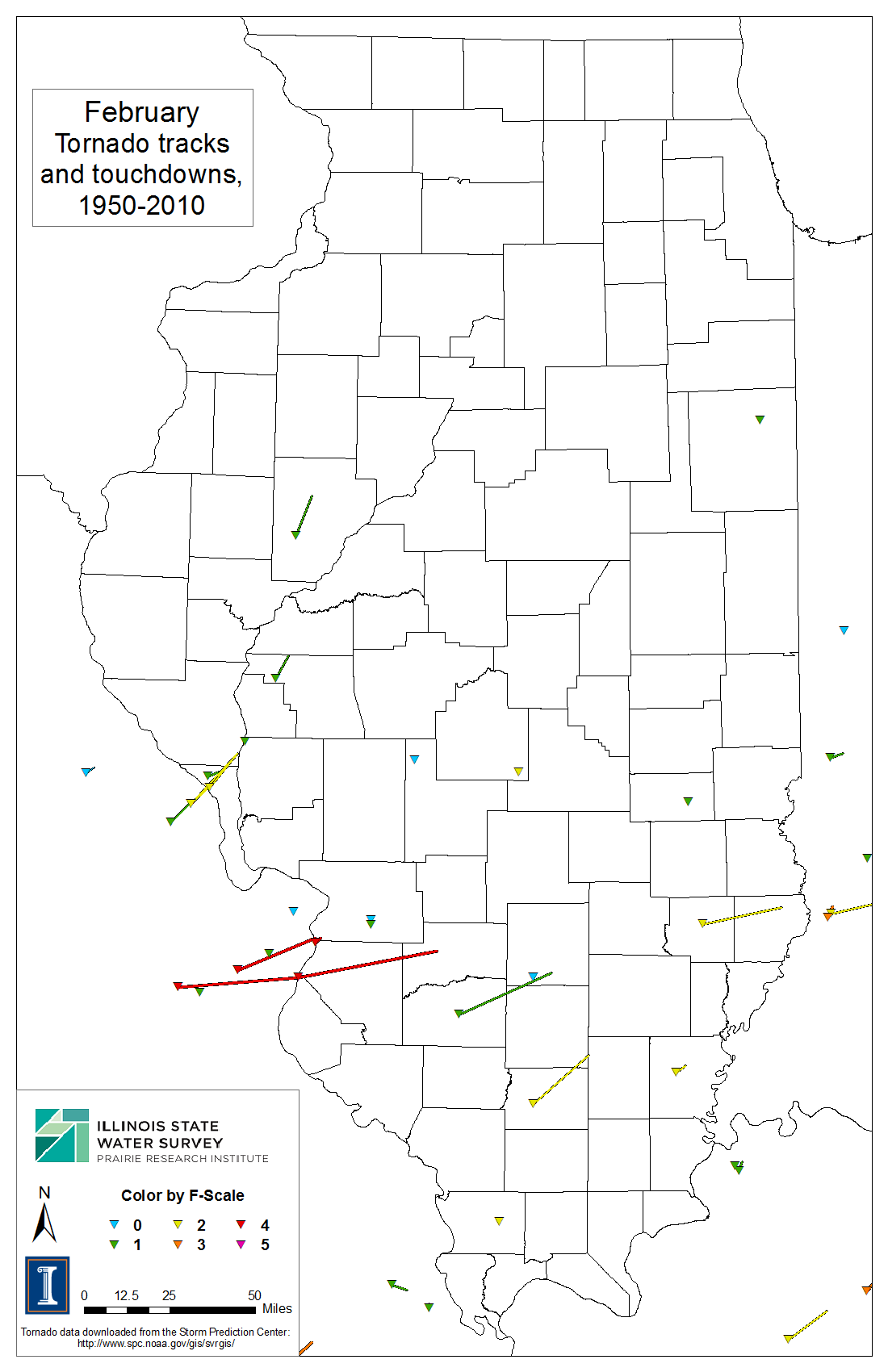
Tornadoes are more common in spring and summer, but they can occur in February. A total of 29 39 tornadoes occurred in February from 1950 to 2010 2011, causing 6 deaths and 28 serious injuries. We have a complete analysis of Illinois tornadoes here, including plots and maps. As the map below shows, many of our February tornadoes occur in the southern part of the state.

New Spring Outlook – Warmer and Wetter for Illinois
The NWS Climate Prediction Center has released the new outlooks for March as well as March-May.
One of the key things to come into play is the status of La Niña in the Pacific Ocean. A La Niña event occurs when ocean temperatures are colder-than-normal along the eastern part of the Pacific Ocean basin. The associated ocean and atmospheric pattern tends to give us a wet spring in states along the Ohio River Valley. CPC states that “La Niña is likely to transition to ENSO-neutral conditions during March-May 2012.” That’s government-talk for saying that the La Niña event is fading fast and will be gone before the end of spring.
The outlook for March in Illinois calls for an increased chance of above-normal temperatures and above-normal precipitation. The outlook for March-May calls for an increased chance of above-normal temperatures throughout the state. However, it shows an increased chance of above-normal precipitation in the eastern half of the state while the western half has “equal chances” of above-, below-, near-normal precipitation.
The new outlook for June-August (maps below), the heart of the growing season, is for an increased chance of above-normal temperatures in southern Illinois and “equal chances” for the rest of the state. The entire state is in “equal chances” with respect to precipitation.
Just a note on “equal chances”. That’s the NWS way of saying that none of their forecasting techniques are indicating a higher risk of unusual temperature or precipitation patterns.


Halfway through February – Warm and Dry in Illinois
We are halfway through February here in Illinois. The statewide average temperature through February 14 was 32.2 degrees, 6.2 degrees above normal.
The statewide average precipitation was 0.66 inches, about 86 percent of normal (first map). It has a quiet month for snowfall as well with most areas reporting 2 inches or less (second map). That’s about ten times less than the first 14 days of last February (last map).


Year without Winter in Chicago?
The folks at the Chicago NWS office raised the following question. I would add to this that last winter Chicago O’Hare reported 57.9 inches of snow and 67 days with an inch or more of snow on the ground. This winter, through February 13, O’Hare reported 15.4 inches of snow and only 10 days with an inch or more of snow on the ground.
ANYONE UP FOR DUBBING 2011-2012 AS THE YEAR WITHOUT A WINTER? SO FAR
THAT HAS CERTAINLY BEEN THE CASE. SO FAR YEAR (THROUGH FEB 11)
CHICAGO HAS HAD THE 8TH WARMEST WINTER TO DATE AND ROCKFORD HAS HAD
THEIR 4TH WARMEST WINTER TO DATE. THE LAST TIME CHICAGO SAW A WINTER
THIS WARM UP UNTIL THIS POINT WAS 80 YEARS AGO BACK IN 1932!
TO PUT THINGS INTO PERSPECTIVE HERE`S A BREAKDOWN ON THE TALLY OF
ABOVE AND BELOW AVERAGE DAYS SO FAR THIS WINTER (THROUGH FEB 12TH):
                    CHICAGO         ROCKFORD
10F+ ABOVE AVG        43%             42%
ABOVE AVG             35%             34%
AVERAGE                4%              5%
BELOW AVG             15%             15%
10F+ BELOW AVG         3%              3%

