The impact of the February 1-2, 2011, storm on highways in Illinois was significant. Using snowfall data and Illinois DOT highway data, our GIS specialist Zoe Zaloudek was able to calculate the number of miles of interstate, US highways, and state roads covered by selected amounts of snow.
Below is the resulting map showing both the roads and significant snowfall. A table at the bottom of the map shows the number of miles affected by 6, 8 and 12 inches or more of snow. The impacts were felt all the way from Quincy to Chicago. We chose a starting point of 6 inches as the threshold for significant disruption of traffic and higher removal cost, based on earlier studies in Illinois.
For example, about 1,132 miles of interstate roads in Illinois received 12 inches or more of snow. Including 1,762 miles of US highways and 4,099 miles of state roads, it adds up to an incredible 6,993 miles of roads with a foot or more of snow to plow.
These estimates do not include the thousands of miles of county roads as well as city streets and alleys in the Chicago metropolitan area and elsewhere. However, we did not have a complete database of those road systems. Also roads covered by less than 6 inches of snow were treated as well for additional costs.

Snowy Winter in Illinois
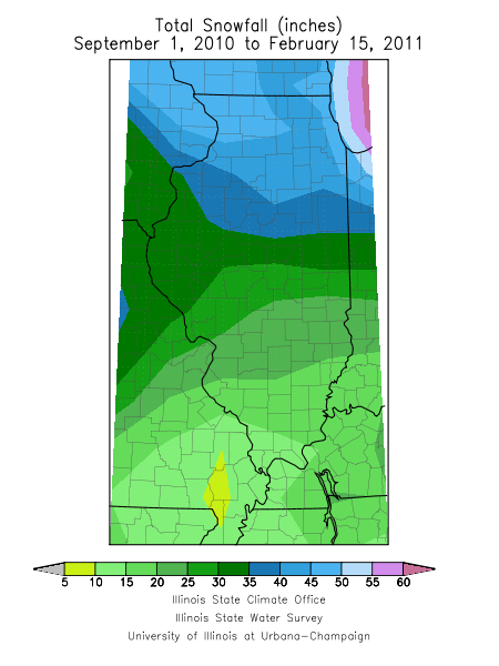
Does it seem like this has been an unusually snowy winter in Illinois? The answer is yes. We are halfway through February and the snowfall totals for this winter are already impressive. Amounts range from about 10 to 20 inches in southern Illinois, 15 to 35 inches across central Illinois, and 35 to over 50 inches in northern Illinois. See first map.
The second map shows the snowfall departure from normal for the period ending on February 15. Essentially all of Illinois has experienced above normal snowfall so far in the season. The southern half of the state is about 4 to 12 inches above normal. Meanwhile, the northern half of the state is about 12 to 24 inches above normal.


Over 10 Million in Illinois Impacted by Storm
The February 1-2, 2011, blizzard crossed through much of central and northern Illinois. By overlaying the snowfall map over the 2000 Census data using GIS software, we can estimate the number of people in Illinois affected by the storm. A rule of thumb in winter storms is that economic impacts become significant in areas with 6 inches or more of snow.
From the map, about 10.9 million Illinois residents were in areas with 6 inches or more of snow in the February 1-2 storm. Furthermore, about 9.8 million Illinois residents were in areas with 12 inches or more of snow. And about 1.5 million Illinois residents were in areas with 18 inches or more of snow.
Disclaimer: all snowfall totals that went into this map are preliminary and subject to change. The census data are from 2000 and may not reflect current population levels.

January Climate Stats
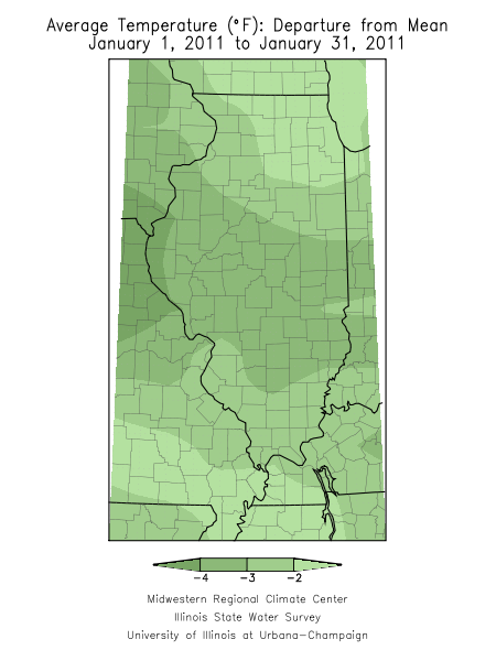
The average statewide temperature for January in Illinois was 21.8 degrees, 3 degrees below normal. That’s warmer than last January when the statewide temperature was only 20.3 degrees and a far cry from the record low January of 1977 when the average temperature was only 10.3 degrees.
The warmest temperature of the month was in Cairo with 67 degrees on January 1. The coldest temperature of the month was in Mt. Carroll with -20 degrees on January 21.
Snowfall was close to normal across much of the state. Amounts ranged from 4 inches in far southern Illinois to over 12 inches in parts of western and northeastern Illinois. Spring Grove, along the Illinois-Wisconsin border, reported the largest snowfall amount in the state with 15.1 inches.
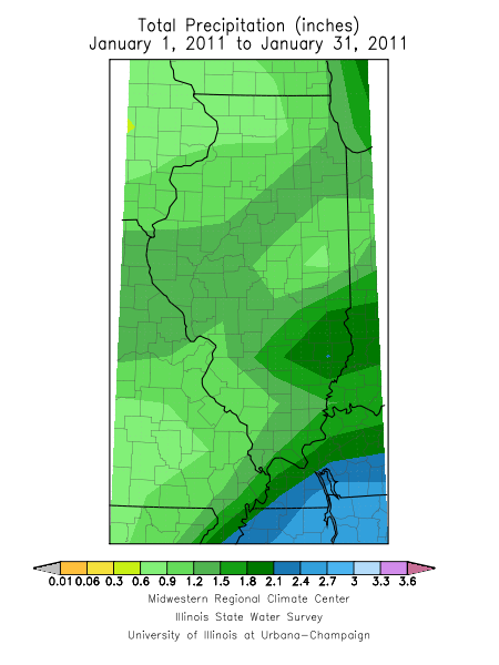
While snowfall was close to normal in most areas, the statewide precipitation (rainfall + water content of snow) was only 1.23 inches, 0.7 inches below normal. Olney reported the largest monthly precipitation amount in the state with 2.81 inches.
Update: added maps for January snowfall, precipitation and temperature departures on February 4.


